Most people have opened a map app and seen their location dot land somewhere odd. Usually a building or a blocked sky is to blame. Lately, though, aviation and shipping news keeps describing the same thing happening on purpose. Two words come up again and again: jamming and spoofing.
The words often travel together, but they do different jobs. One buries a signal so it cannot be used. The other supplies a fake signal so the receiver trusts a wrong answer.
So why is satellite navigation open to both, and why do aviation safety agencies worry more about deception? And what do the laws and international rules look like?
Blocking versus deceiving
The European Union Aviation Safety Agency (EASA) splits them in a single line: jamming blocks a signal, while spoofing feeds the aircraft's own receiver with false information. Blocking stops the receiver from hearing what it needs. Deceiving gets the receiver to accept what it hears and reach a wrong conclusion.
Picture asking for directions in a noisy restaurant. If the next table is so loud that you cannot make out any answer, that is close to jamming. If someone poses as a waiter and gives you clear but wrong directions, that is close to spoofing. The real case differs, because a machine, not a human ear, receives the radio waves and does the math, so even a wrong answer comes out as convincing numbers.
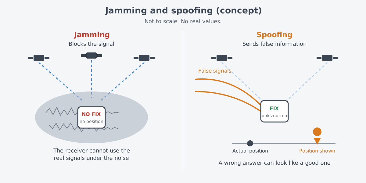
The same two words appear in military writing. A Congressional Research Service (CRS) report gives a general description of electronic warfare. It uses the electromagnetic spectrum to find, eavesdrop on, block and trick, or "spoof," an enemy's radars, radios, data links and other electronic gear.
Stopping an enemy from doing the same also counts as electronic warfare. For the bigger picture, start with Electronic warfare: the invisible contest.
Why satellite signals are easy to disturb
Satellite navigation is the target that makes the news most often. Take the U.S. Global Positioning System (GPS). Its satellites broadcast, in one direction only, signals that carry each satellite's current position and the time.
A receiver picks these up and works out its own three-dimensional position and time. The key point is that the receiver never asks the satellite anything back. It simply takes in what arrives and calculates.
Those signals travel a long way. GPS satellites circle in medium Earth orbit, about 20,200 km up. The Cybersecurity and Infrastructure Security Agency (CISA) notes that by the time GPS signals reach the ground they are very weak, so unwanted transmissions can swamp them with little effort. It is like a quiet voice from far away being drowned out by a loud one close by.
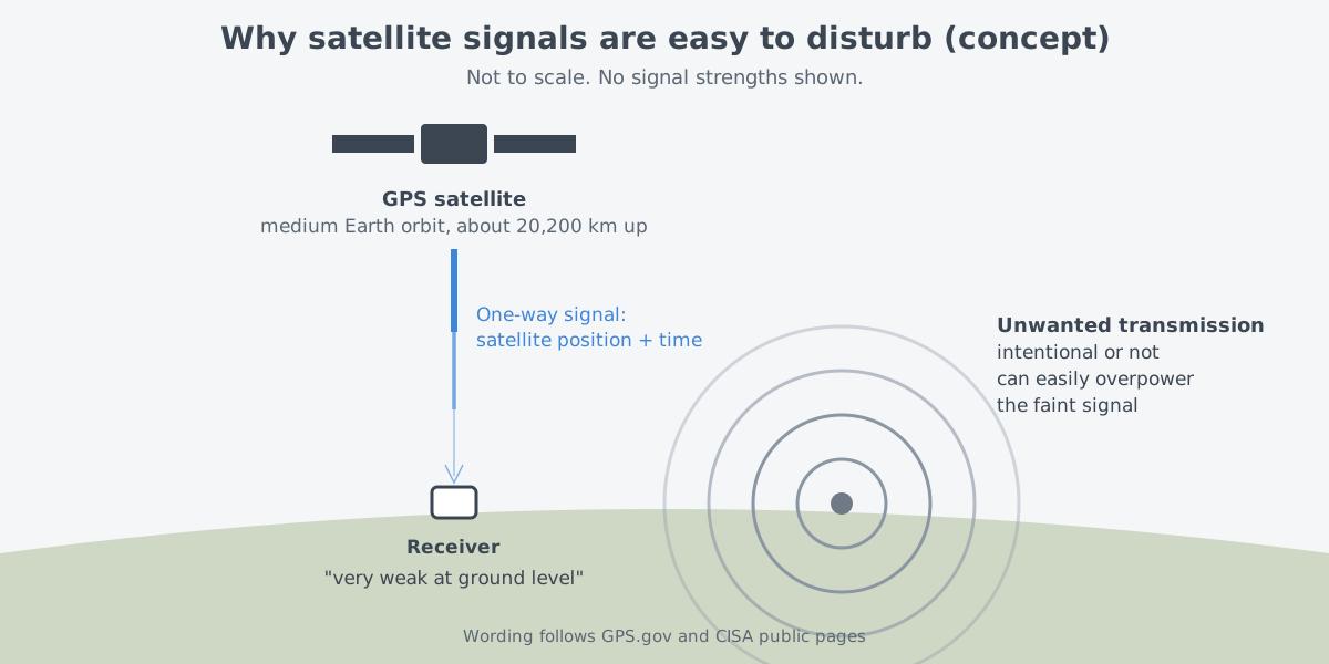
Satellite navigation uses radio waves at set frequencies. GPS relies on frequencies set aside for radio navigation, so keeping the service running means shielding those frequencies from interference. Interference can come from radio emissions in nearby bands, from jamming that is deliberate or accidental, and from natural space weather. A broken or badly configured transmitter can also leak signals into the same frequency range.
Position is not the only thing at stake. Every GPS satellite carries several atomic clocks that put very precise time into the signal. Communications networks, timing in the power sector, and time stamps on bank and financial transactions all lean on it. How position and time come from the same signals, and how inertial navigation pairs with them, is covered in Inertial and satellite navigation: knowing where you are.
Why deception is the harder problem
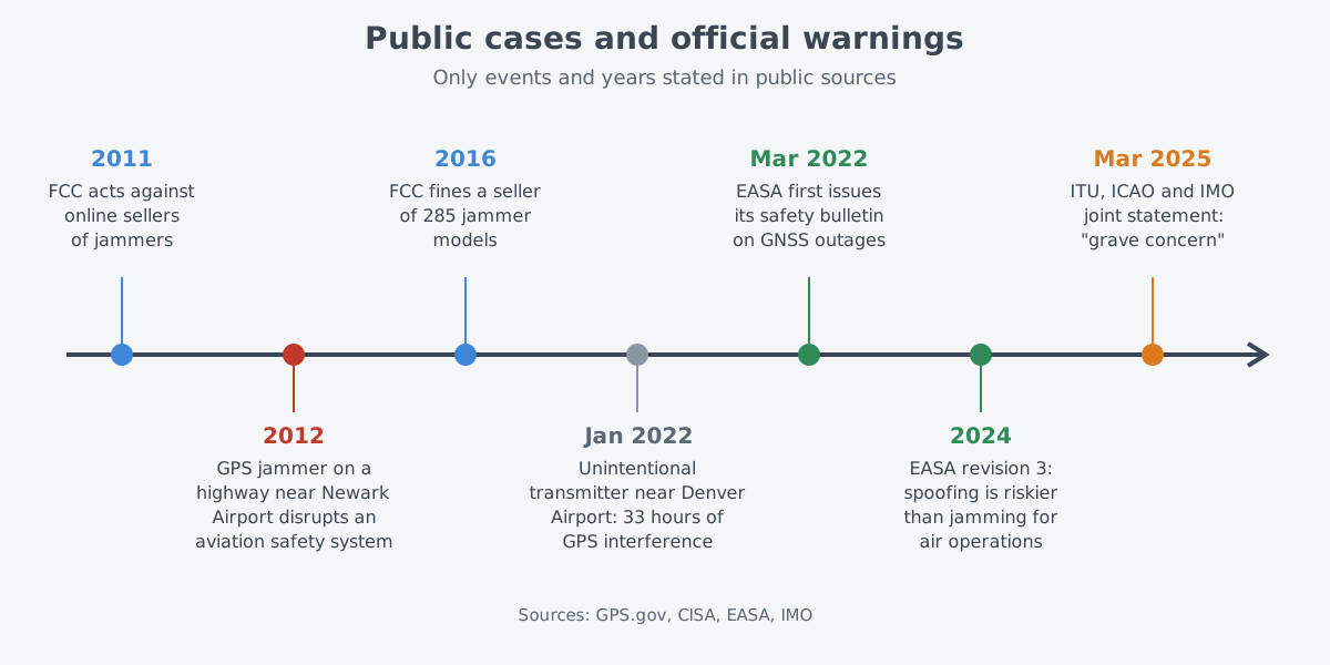
So which is more dangerous, jamming or spoofing? EASA first issued Safety Information Bulletin (SIB) 2022-02 on satellite navigation disruptions on March 17, 2022. The third revision, announced in 2024, states plainly that spoofing poses a greater risk to air operations than jamming does.
EASA gives two reasons. Spoofing is harder to detect. It can also reach several systems at once, and when more than one system is hit the effects add up. Back in the restaurant, you notice noise right away, but you discover that a confident wrong answer was wrong only after you have followed it.
The third revision also drew on recent events. In some cases pilots responded to false terrain warnings. The terrain awareness and warning system called for a "pull-up" that was not real, and following it led to steep climbs that were not coordinated.
The second revision was issued to alert operators to jamming and spoofing, especially near conflict zones. Information on affected airspace was later moved out of the bulletin to a separate web page that can be updated as new reports come in.
What public cases show
Not every case is deliberate. In January 2022, near Denver International Airport in the United States, one transmitter broadcasting by mistake in the GPS frequency caused 33 hours of GPS interference. Aircraft pilots were the first to notice.
The enforcement bureau of the Federal Communications Commission (FCC) went out, found the transmitter and coordinated shutting it off. The investigation confirmed that it had been sending the signal unintentionally.
Nobody was hurt and there were no accidents, yet several critical infrastructure sectors were affected. Many of the systems that picked up the interference had a backup time source built in, and they saw little or no effect. The case shows why depending on satellite signals alone is a risk.
Deliberate jamming cases are public too. In 2012, a person illegally ran a GPS jammer on a highway outside Newark Airport and disrupted an aviation safety system. In August 2013 the FCC proposed a penalty of almost $32,000.
Sellers are also targeted. In October 2011 the FCC announced 20 actions aimed at web sellers across 12 states. In May 2016 it fined a company $34,912,500 for marketing 285 different jammer models to U.S. customers over more than two years.
Someone is also watching. The U.S. Space Force's Joint Commercial Operations (JCO) puts out daily, unclassified "heat maps" of intentional positioning, navigation and timing interference and spoofing around the world.
The same two ideas in radar and communications
Blocking and deceiving are not limited to satellite navigation. Radar also sends out radio waves and judges what comes back, so the same two ideas apply. CRS reports that the U.S. Department of Defense is studying how faster computing could improve electronic deception, or spoofing. One example it gives is false radar returns that make an opponent's targeting harder.
There is also an older trick that uses a visible decoy. Chaff, strips of metal that create fake echoes, is explained along with its history in Chaff and flares: the sparks behind an aircraft. The basics of how radar measures range with radio waves are in Radar: measuring distance and motion with radio waves.
In communications, light can be part of the answer. CRS explains that, unlike radio, a laser carries the link in a narrow beam, which greatly lowers the risk of jamming or disruption in point-to-point links between satellites. Even a narrow laser beam spreads a little with distance, though. How much a beam spreads is the topic of Why a beam spreads: divergence, focus and aperture.
Law and international rules
In the United States, a jammer is not something a private person may use. Federal law bans operating, marketing or selling any device that disrupts permitted radio services such as cell phones, police radar and GPS. A jammer can even block 911 and other emergency calls.
There is no exception for a business, classroom, home or vehicle, and local police cannot use jammers on their own authority. Using or selling one can bring large fines, seizure of the device, and criminal penalties that include prison.
International rules start from the fact that radio waves cross borders. Article 4.10 of the ITU Radio Regulations deals with safety. In it, member states accept that radio navigation and other safety services need special measures to stay free of harmful interference.
In shipping, the Maritime Safety Committee of the International Maritime Organization (IMO) issued circular MSC.1/Circ.1644. It urged member states to cut down interference that starts on their own soil, as the ITU Radio Regulations require. It also asked them to consider warning mariners about the times and areas of known interference.
In March 2025, three UN specialized agencies spoke together. The IMO joined the International Telecommunication Union (ITU) and the International Civil Aviation Organization (ICAO). Their joint statement voiced "grave concern" over growing jamming and spoofing that targets satellite navigation. The statement asks member states to do five things.
| # | Action named in the joint statement |
|---|---|
| 1 | Protect satellite radio navigation, known as RNSS, from harmful interference that hurts civilian and humanitarian work |
| 2 | Make navigation, positioning and timing systems that rely on satellites more resilient |
| 3 | Keep conventional navigation infrastructure for emergencies |
| 4 | Get regulators, aviation, shipping, defense and law enforcement bodies working together more closely |
| 5 | Set up ways to report interference |
The third item echoes the lesson from Denver: keep another path to rely on when the satellite signal falters. Shipping rules carry the same idea. The International Convention for the Safety of Life at Sea (SOLAS) covers every ship, whatever its size. Each must carry a satellite navigation receiver, a land-based radio navigation system, or some other suitable means.
What to read next
- Inertial and satellite navigation: knowing where you are: see how inertial navigation fills the gap when satellite signals falter.
- Electronic warfare: the invisible contest: the three official divisions of electronic warfare, where jamming and spoofing belong.
- Chaff and flares: the sparks behind an aircraft: how visible decoys fool radar and infrared seekers, and where they came from.