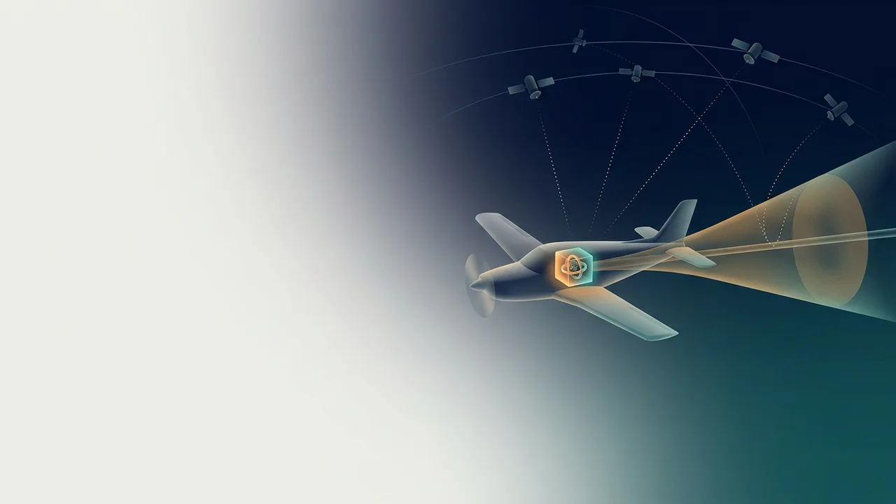
In places where the sky is hidden, such as an underground parking garage, the blue dot on a phone map often stalls. For a moment, the location you always rely on is gone. So how does a vehicle flying where it cannot count on signals from the sky know where it is?
There are two methods. Inertial navigation works out position from the motion it feels, without looking outside at all, while satellite navigation learns position and time from signals sent by satellites. Their strengths and weaknesses cross over each other.
Inertial navigation: working it out without looking outside
Imagine walking with your eyes closed. If you count how many steps you took and in which direction, you can roughly guess how far you are from where you started. Inertial navigation also starts from a known point and adds up its motion from there. The real thing differs in one way: it measures acceleration and rotation, not steps.
A technical journal from the Johns Hopkins University Applied Physics Laboratory (APL) explains the idea. An inertial navigation system (INS) senses the acceleration and the rate of turning that act on the body, and from them gives position, velocity, acceleration, attitude and turning rate. On a missile, this information supports guidance and flight control for the whole flight. During the boost phase right after launch, when the missile gains speed, inertial guidance is typically used.
Two kinds of sensors do the measuring. Gyroscopes sense changes in angle, and accelerometers sense changes in velocity. A package holding three gyros and three accelerometers, all set at right angles to each other, is called an inertial measurement unit (IMU).
The great strength of inertial navigation is that it needs nothing from outside. Even when the sky is blocked and no radio waves get through, the sensors keep the count going from the body's own motion.
When small errors pile up
That strength has a price. With your eyes closed, one step may be only a little off. After a hundred steps, though, you can end up well away from where you thought you were. Inertial navigation also builds each answer on the last one, so small errors grow as time passes.
The program pages of the U.S. Defense Advanced Research Projects Agency (DARPA) for its Micro-PNT effort describe this problem from several sides. One project aimed to curb the growing error seen when inertial sensors are used by themselves. Another tried to stop error building up as turning-rate data is integrated. A third dealt with drift, the slow, long-term shift in the calibration of tiny machined (MEMS) inertial sensors.
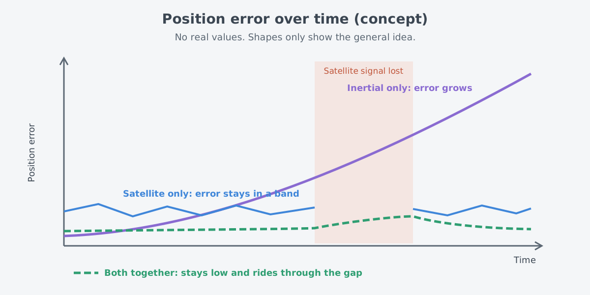
So inertial navigation is often not left to run alone for long; it is corrected from time to time by other measurements. On spacecraft too, inertial sensors are often used to carry the vehicle's state forward in between updates from non-inertial sensors. The best-known of those other measurements is satellite navigation.
Satellite navigation: clocks and distances in the sky
Long ago, sailors read the star patterns overhead to work out where they were. NASA's science website for young readers compares GPS satellites to the stars of a constellation, because the places of both at any moment are known. A receiver listens to satellite signals and works out its distance to each satellite. Once it knows the distance to four or more of them, it knows its own position.
GPS, the Global Positioning System, is a utility owned by the United States that offers services for positioning, navigation and timing (PNT). The system has three parts: the satellites of the space segment, the ground facilities of the control segment, and the receivers in our hands, the user segment.
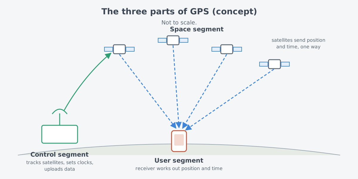
In the space segment, a nominal 24 satellites send out one-way signals that carry each satellite's current position and time. The United States has committed to keeping at least 24 operational satellites available 95% of the time. For more than ten years, 31 of them have been flying under the U.S. Space Force. The satellites travel in medium Earth orbit about 20,200 km up and go around the planet twice a day.
The layout has a purpose. The satellites are spread over six evenly spaced orbital planes, so that from nearly any spot on Earth at least four of them are in view. That is what lets a receiver measure "the distance to four or more satellites" almost anywhere.
The control segment is a network of ground facilities spread around the world. It tracks the satellites, watches their signals, analyzes them, and sends commands and data up to them. Keeping the satellites in the right orbits, adjusting their clocks and loading fresh navigation data are also its jobs.
GPS gives more than position. Every GPS satellite carries several atomic clocks, and the signals carry precise time information. A receiver decodes those signals and falls into step with the atomic clocks. So users can pin down the time with an error under 100 billionths of a second, with no atomic clock of their own.
GPS serves military users as well as civilians. Anyone may use the civilian service free of charge, without a break, anywhere in the world.
GNSS: there is more than GPS
Satellite navigation is often just called GPS, but GPS is one system among several. The general name for satellite navigation systems is GNSS, for global navigation satellite system. Any group of satellites that offers positioning, navigation and timing services, whether worldwide or for one region, falls under that name.
The other systems GPS.gov describes are these.
| System | Run by | Coverage | As described by GPS.gov |
|---|---|---|---|
| BeiDou (BDS) | China | Global | Formally in service in 2020, 35 satellites |
| Galileo | European Union | Global | Initial services started in 2016 |
| GLONASS | Russia | Global | Fully operational system of 24+ satellites |
| NavIC (IRNSS) | India | Regional | 7 satellites |
| QZSS | Japan | Regional | Services started in 2018, now 7+ satellites |
Japan's QZSS is a regional system that supports GPS and widens coverage over East Asia and Oceania. GPS.gov explains that several nations run or are building their own systems, to have navigation and timing capability that both supports other systems and stands on its own.
The weak spot of satellite signals
Satellite navigation does not pile up error, but it depends on signals. GPS uses radio frequencies set aside for radio navigation, and keeping the service going means guarding those frequencies against interference. Interference can come from radio emissions in neighboring bands, from jamming, whether deliberate or not, and from natural space weather.
Jamming is also barred by law. In the United States, ordinary consumers may not legally use signal jammers. The wider contest over radio waves is the subject of Electronic warfare: the invisible contest.
For the military, this weak spot weighs even more. DARPA writes that for decades GPS has been built into vehicles and munitions for precise guidance and navigation. It adds that relying on GPS becomes a serious weakness when the signal is weakened or missing. That is why it developed small inertial sensors for fully self-contained inertial navigation, so that precise guidance can work without GPS.
Why the two are used together
Set the two methods side by side and the answer appears. Inertial navigation keeps working without anything from outside, but its error piles up. Satellite navigation does not pile up error, but it needs a signal. The weakness of one is the strength of the other.
A 1991 paper by researchers at Ohio University, posted on NASA's technical reports server, shows the pairing well. In the test system they built, the inertial unit handled navigation data only over short spans, while GPS supplied the stability over long spans. The researchers wrote that because the two give similar information, using them together lets a failed sensor be found and singled out reliably.
The same pairing shows up in weapons. The Congressional Research Service (CRS) says the small glide bomb SDB I is guided by an inertial navigation system aided by GPS. In the CRS list of guidance parts for precision-guided weapons, inertial measurement units and GPS receivers appear side by side.
Light inside gyros
The word gyro may call up a spinning top. Today's gyros come in many other kinds. NASA's material names two kinds as common in small spacecraft today: MEMS gyros and fiber optic gyros (FOGs). It says fiber optic gyros usually perform better but weigh and cost more.
There are also resonator gyros and ring laser gyros. Their size, weight, power needs and cost, however, make them uncommon on small satellites. Fiber optic gyros and ring laser gyros, as the names say, have optical fiber or a laser inside.
How an optical fiber holds light in and carries it is the subject of How a fiber guides light: core and cladding. How laser light differs from the light of a bulb is covered in What is a laser? How it differs from a light bulb.
What to read next
- Electronic warfare: the invisible contest: looks at interference and jamming of satellite signals within the larger contest over the electromagnetic spectrum.
- How a fiber guides light: core and cladding: covers the fiber principle behind fiber optic gyros.
- What is a laser? How it differs from a light bulb: covers the basics of laser light, which gives the ring laser gyro its name.
- Measuring with lasers: range finding and lidar basics: shows another case of laser light put to work in measuring.
- Air-to-air missiles: what the missile sees: looks at the missile's seeker.