The weather map that shows where the rain clouds are and the air traffic control that guides planes at an airport rely on the same kind of device. It is called radar. Instead of looking, it uses radio waves to find how far away an object is and how fast it is moving.
Two ideas do the work. Distance comes from the time a radio wave takes to go out and come back, and motion comes from the Doppler effect. Both come from reading the pulse that bounces back from an object.
What radar is: send radio waves and read what returns
Radar works by sending out radio waves and detecting any reflections from distant objects. That is why radar is sometimes described as "seeing" with radio waves. The US National Oceanic and Atmospheric Administration (NOAA) explains in its weather lessons that radars use radio waves to find the distance and velocity of the targets they hit.
The basic layout is simple. A radar needs a transmitter that sends out radio signals and a receiver that catches the energy reflected from targets. The Weather Radar Center of the Korea Meteorological Administration (KMA) breaks a weather radar into five parts.
- Transmitter: makes the electromagnetic waves the antenna will send out.
- Antenna: gathers those waves into one direction, sends them into the air and receives the waves that come back.
- Receiver: takes the returning waves from the antenna, turns them into a digital signal and passes it to the signal processor.
- Signal processor: processes that signal into observed values such as reflectivity and radial velocity.
- Radome: a dome-shaped structure that protects the radar from strong winds and similar hazards.
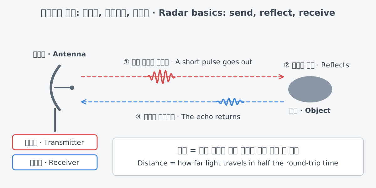
Radar differs from a camera because it sends out its own energy. NASA classes synthetic aperture radar (SAR), one kind of radar, as "active" data collection. The instrument sends a pulse of energy and then records how much of it comes back after interacting with Earth. Optical imagery, which only receives energy coming from the scene, is a "passive" technique.
The wavelength is different from visible light, too. Radar instruments use longer wavelengths, at the centimeter to meter scale. That lets them make images of land that is covered by clouds or hidden under a dense canopy of trees.
Measuring distance: the round-trip time
Take the WSR-88D, the radar that makes up the US weather radar network. It does not send a continuous stream of radio waves. It sends very brief pulses instead. The pulses travel at the speed of light, and between pulses the radar listens for returns.
So the radar sends, listens and sends again. On the WSR-88D the same antenna both transmits and receives, so one antenna takes turns doing the two jobs.
Distance comes from time. The radar measures how long a pulse takes to go out, strike a target and return to the antenna, and from that it finds the range to the target. That time covers both the trip out and the trip back. So the distance to the target is how far light travels in half of the round-trip time.
Airport radar works on the same idea. The Airport Surveillance Radar (ASR-11) of the US Federal Aviation Administration (FAA) sends out electromagnetic waves that travel in a straight path. When the beam meets an aircraft or another object, it reflects from the surface back to the antenna, and the time that echo takes gives the distance to the aircraft.
Measuring speed: the Doppler effect
When an ambulance comes toward you with its siren on, the pitch sounds high, and it drops as the ambulance goes by. As a source approaches, its sound waves are compressed and the pitch is higher; as it moves away, the waves are stretched, which gives a lower frequency. This change caused by motion is called a Doppler shift, and the effect behind it is the Doppler effect. NOAA compares radar speed measurement to this change in sound.
A Doppler radar applies the same idea to radio waves. When it sends a pulse, it keeps track of the pulse's phase and amplitude. If the pulse hits a moving target, the returning wave comes back with a shifted phase, and the radar uses this phase shift to find the target's speed.
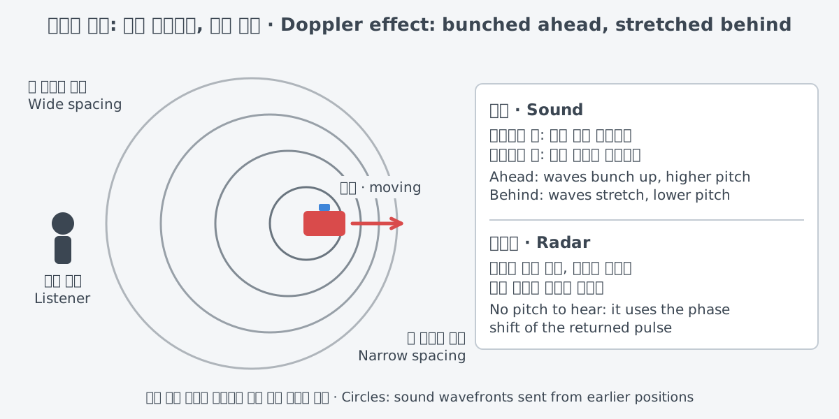
The sound comparison only goes so far. A real radar does not listen for a change in pitch; it compares the phase of the pulse it sent with the phase of the pulse that came back. There is another difference, too. Radar cannot measure every part of an object's motion.
A radar sits in one place. So it can only measure how fast a target is moving toward it or away from it. That speed is called radial velocity. Radial velocity equals the true speed only when the target moves directly toward or directly away from the radar.
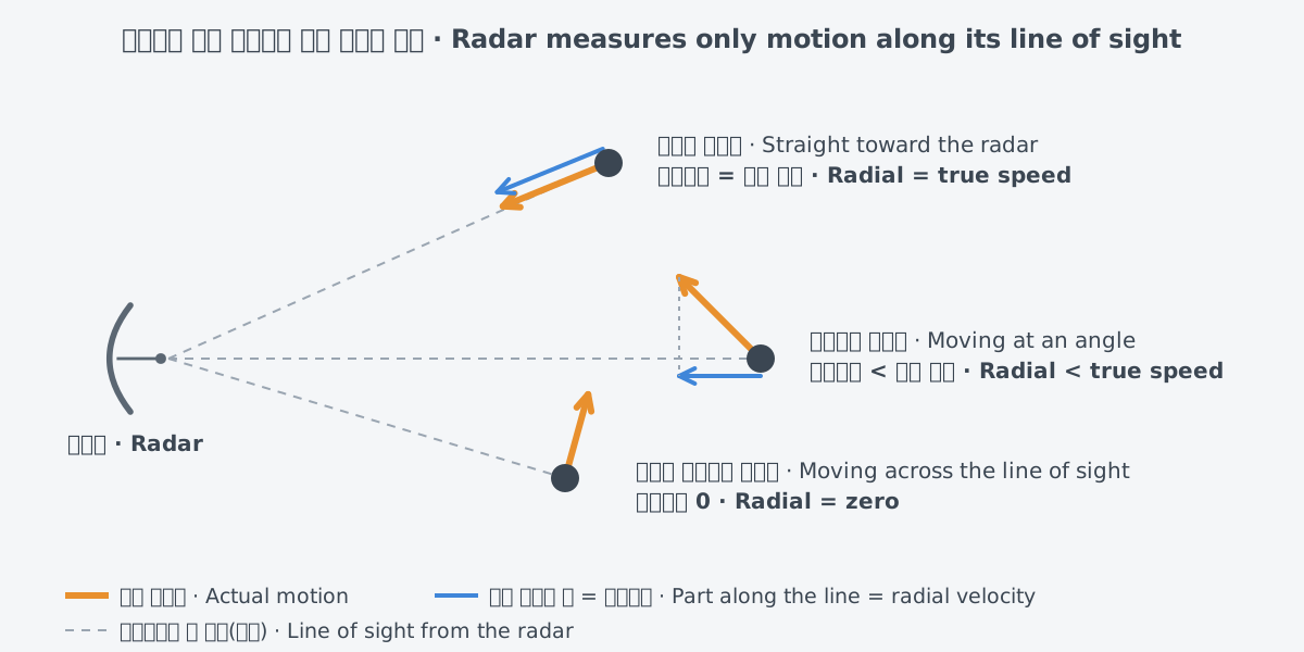
That is why NOAA points out that radial velocity is almost always less than true velocity. Weather radar wind images show this difference: where the wind blows across the beam at a right angle, radial velocity reads zero. The KMA Weather Radar Center also warns that radial velocity seen by radar does not show an object's actual speed of travel.
How direction and height are found
Distance alone does not say which way an object lies. The radar also needs to know where the beam was pointing. The ASR-11 uses a continually rotating antenna on a tower and measures the time of the echo together with the azimuth, or direction, of the beam. The aircraft's actual position comes from combining that distance and azimuth.
Height is found in different ways depending on the job. The WSR-88D raises its antenna through a set of predefined elevation angles, one after another. There can be as many as 15 of them, which lets forecasters look at storms at many heights above the ground instead of just one.
The beam gets much higher above the ground with distance. So the angle the beam was raised to and the distance from the radar, taken together, tell how high above the ground the beam is passing. NOAA gives an example: at 100 miles from the radar, even the lowest elevation angle of 0.5° is about 12,000 ft above the ground.
The shape of the beam matters as well. NOAA names two beam traits to keep in mind when reading radar images. One is that the beam spreads as it moves farther from the radar, and the other is that it bends as it travels through the air, which is called refraction.
Drawings often show the beam as a cone with sharp edges. NOAA suggests it is better to picture it like the light of an ordinary household flashlight. The likeness stops at the shape. A radar beam is invisible radio energy, and it also bends in the atmosphere.
In air traffic control, height can come from somewhere other than the echo. The ASR-11 combines a primary radar and a secondary radar. The primary radar receives the echoes that come back from objects. Military, commercial and some general aviation aircraft carry transponders that answer a signal from the secondary radar by automatically reporting an identification code and altitude.
Radar outside the military: weather and aviation
All modern weather radars are Doppler radars. Pulsed Doppler weather radars produce three base products, and the one forecasters use most often to see where precipitation and severe weather are occurring is reflectivity. Reflectivity is the amount of energy that returns to the receiver after a pulse hits a target.
There is a catch. The radar does not measure rainfall intensity directly; it only measures how much power comes back to it. Generally, higher reflectivity means heavier precipitation, but that is not always the case.
The second base product is velocity. It shows the motion and speed of targets, and by convention it uses color. Green shows wind blowing toward the radar, with negative values. Red shows wind blowing away from the radar, with positive values.
The electric field of a radio wave oscillates, moving back and forth, and that oscillation has a direction. For light this direction is called polarization, and the same word is used for radio waves. In 2012 the US network of WSR-88D radars was upgraded to dual polarization. According to NOAA, dual-pol radar helps forecasters clearly identify rain, hail, snow, the rain/snow line and ice pellets.
The Korea Meteorological Administration also uses dual-polarization radar, which sends and receives horizontally and vertically polarized waves at the same time. With it, the KMA gets the horizontal size of precipitation particles, their vertical size and the ratio between the two all at once. From the horizontal and vertical signals and the difference between them, it works out precipitation intensity and the type and form of precipitation, such as snow, rain or hail. According to the KMA Weather Radar Center, a dual-polarization Doppler weather radar basically produces seven kinds of raw data, including reflectivity and radial velocity.
For air traffic control, the FAA's ASR-11 is deployed at terminal air traffic control sites. The primary radar finds an aircraft's distance and azimuth from echoes, and the secondary radar receives the identification code and altitude from its transponder. The table below adds Earth observation to these two uses, along with one military use from history for comparison.
| Use (civil/military) | Example | What the radar tells you |
|---|---|---|
| Weather observation | The US WSR-88D, the KMA dual-polarization radar | Where precipitation is (reflectivity), whether wind is moving toward or away from the radar (radial velocity), rain versus snow versus hail (dual polarization) |
| Air traffic control | The FAA's ASR-11 | An aircraft's distance and azimuth, plus the identification code and altitude reported by its transponder |
| Earth observation | Synthetic aperture radar (SAR), as described by NASA | Images of land covered by clouds or forest |
| Air-defense warning (military, history) | Britain's Chain Home in World War II | Advance warning of incoming air raids |
The name "RADAR" and how it began
The word radar comes from the acronym radio detection and ranging. It means finding objects (detection) with radio waves (radio) and measuring how far away they are (ranging). Both jobs, finding and measuring distance, are right there in the name.
The name was chosen by the US Navy in 1940. An article by David Boslaugh on the IEEE history wiki tells the story. Two officers in the Office of the Chief of Naval Operations, Lieutenant Commanders Furth and Tucker, needed a short name that did not have to be kept secret. They settled on this acronym.
The Chief of Naval Operations, Admiral Stark, announced it in a letter he signed on November 18, 1940. The British kept the name RDF until 1943, when all the Allies agreed on "RADAR."
The technology has deeper roots. In 1904 the German Christian Hülsmeyer patented a way to find distant objects by the reflection of radio waves, but the invention attracted very little interest. What changed things was the threat of air attack in the late 1930s. Research groups in at least eight countries, France, Germany, Italy, Japan, the Netherlands, the Soviet Union, the United Kingdom and the United States, developed radar independently.
On February 12, 1935, Robert Watson-Watt sent a memorandum titled "Detection of aircraft by radio methods." Hanbury Brown called it "the birth certificate of radar." Even before the war began, Britain had built an air-defense radar system called Chain Home, and during the 1940 Battle of Britain it warned of coming German air raids.
Radar changed a great deal during the war. One of the most important advances was the move to higher frequencies, and so shorter waves, especially into the microwave region. Shorter wavelengths were easier to focus into narrow beams, and higher frequencies gave greater resolution, the ability to tell finer details apart.
The key technology behind that move was the cavity magnetron. Two British researchers, Randall and Boot, invented it in 1940 at the University of Birmingham. During the war radar also found dozens of other uses, and military meteorologists used it to track storms.
What to read next
- Phased-array radar: instead of rotating the antenna as the ASR-11 does, these radars keep the antenna still and change the beam's direction.
- "Measuring with lasers: range finding and lidar basics": measuring distance with light instead of radio waves.