A bomb is released above the clouds, where the target below cannot be seen. Even so, the bomb heads for the place it was given. It does not get there by looking at the target. It gets there because satellite signals tell it where it is at every moment.
A satellite-guided bomb is an ordinary bomb body with one kit added to its tail. This article looks at what happens inside that kit and why the U.S. military turned to this approach after the Gulf War. It then follows the same idea into small bombs, artillery shells and rockets.
A bomb that does not look at the target
A laser-guided bomb uses a seeker on its nose to watch a spot of light on the target and follow it. A satellite-guided bomb works differently. It has no eye on the front to see the target. Instead it receives the target's location in advance, works out its own position as it flies, and closes the gap between the two.
A 1995 report by the U.S. General Accounting Office (GAO) sorted the information that precision-guided munitions (PGMs) use into a few kinds. They include a target location passed on by a person marking the target, signals from GPS satellites and the weapon's own inertial navigation. A seeker that looks at the target near the end of flight is another, and a mix of these is also possible. JDAM (Joint Direct Attack Munition) was planned to add GPS technology to existing unguided bombs so that they could guide themselves to the target area.
Think of a car running a navigation app. Once a destination is entered, the car watches its own dot on the map and corrects its course without having to recognize the scenery. In reality no one is driving the bomb, and if the destination is wrong, it goes to the wrong place with great accuracy. That difference comes back when the limits are discussed.
Knowing its own position from satellites
The GPS space segment has a baseline of 24 satellites. Each one sends a one-way signal that carries its current position and the time. A receiver picks up these signals and works out its own position in three dimensions, along with the time. The satellites sit in six evenly spaced orbital planes, so at least four can be seen from almost anywhere on Earth.
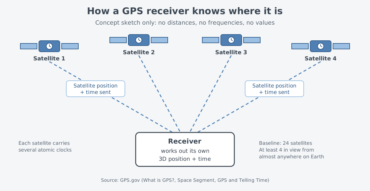
Why does time matter so much? Each satellite carries several atomic clocks, and the signal holds very precise time data. In GPS, time is the fourth dimension after longitude, latitude and altitude. A receiver decodes the signals and, in effect, sets its own clock to the satellites' atomic clocks.
GPS offers a civilian service and a military service. The military service is for U.S. and allied armed forces and approved government agencies. Other countries run their own global navigation satellite systems (GNSS) as well, as covered in Inertial and satellite navigation: knowing where you are.
Two kinds of navigation inside the tail kit
A satellite-guidance tail kit holds more than a GPS receiver. A 2005 National Academies report described the new JDAM tail section as containing an inertial navigation system and a GPS guidance control unit together. With this tail, an unguided general-purpose bomb becomes more accurate in any weather, and each bomb is given its own target and flies there on its own.
Inertial navigation uses an inertial measurement unit (IMU) to track the weapon's own motion without looking outside. According to Johns Hopkins APL, most modern missiles track their own location this way. Their inertial system is set up and updated throughout the flight by an outside reference, most often GPS. A bomb's tail kit uses the same pairing: the inertial system keeps working out the position, and the satellite signals keep correcting it.
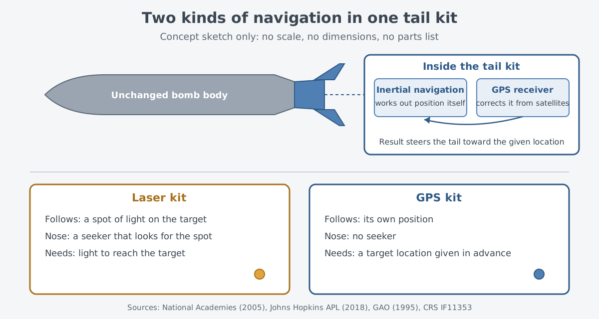
Based on that result, the tail corrects errors during flight and sends the bomb toward the location it was given. The bomb body stays just as it was built. Today's JDAM is a kit that bolts onto the tail of unguided bombs in the 500-, 1,000- and 2,000-pound classes, and every U.S. fixed-wing strike platform can now carry it.
Below the clouds: why satellite guidance
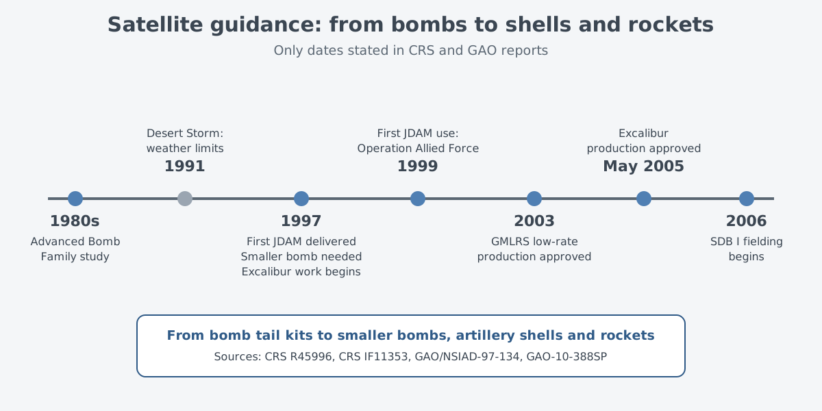
The experience of Operation Desert Storm in 1991 left its mark on the weapons chosen afterward. A 1997 GAO evaluation of that campaign contains this point. Defense Department and service purchase plans included new munitions with GPS guidance. Part of the justification was their ability to reduce the medium-altitude shortcomings and bad-weather limits seen in Desert Storm while keeping pilots and aircraft safer.
JDAM's purpose pointed the same way. It was meant not to replace an existing weapon but to deliver general-purpose bombs accurately in bad weather. Before that, the GPS Aided Munition (GAM) was also being developed as an interim weapon for the B-2 bomber. It was a tail kit made for the 2,000-pound general-purpose bomb, and JDAM was to replace it later.
The U.S. Air Force and Navy began studying such weapons in the 1980s under a program called the Advanced Bomb Family. JDAM deliveries began in 1997, operational testing followed in 1998–1999, and the Air Force first used them in Operation Allied Force in 1999. For what came before, from World War II to the Vietnam War, see Precision-guided bombs: what gets added to a plain bomb.
Bombs get smaller
Better accuracy led to a new question. If a bomb lands closer to its aim point, does it still need to be so large? According to the Congressional Research Service (CRS), the Air Force responded to the accuracy gained from GPS in 1997. It said it needed a smaller bomb that would cause less collateral damage.
The result was the Small Diameter Bomb (SDB), a 250-pound guided bomb. The Air Force started putting SDB I into service in 2006. SDB I is guided by a GPS-aided inertial navigation system and was designed mainly for stationary targets.
Size mattered for another reason too. The SDB was designed around the space inside the F-22 and F-35, so these fighters could carry it internally and keep their low observable signature. That space is called an internal weapons bay, explained in Internal weapons bays: why carry weapons inside. The later SDB II added a seeker that combines millimeter-wave radar with an infrared sensor.
Spreading to shells and rockets
Satellite guidance did not stay with bombs dropped from the air. The same idea went into shells and rockets fired from the ground.
Excalibur is a family of GPS-based precision shells for 155 mm cannon artillery. A 2010 GAO assessment called it "fire-and-forget," meaning it needs no further guidance after firing. Its near-vertical angle of fall was expected to reduce collateral damage and make it more effective in cities.
Development began in 1997. In May 2005 the first increment was approved for production to meet an urgent need in Iraq for artillery that was more accurate and caused less collateral damage. For the guns that fire it, see Self-propelled howitzers: guns that move themselves.
On the rocket side there is GMLRS (Guided MLRS), the guided form of the multiple launch rocket system (MLRS). The U.S. Army history office at Redstone describes GMLRS as a change to the extended-range MLRS rocket to improve its range and accuracy further. The Army approved low-rate initial production of GMLRS in 2003. The launcher story continues in Multiple launch rocket systems: why one vehicle carries many tubes.
Limits: jamming and the quality of the target location
Satellite signals are radio waves that come from far up in the sky. When the 1997 GAO evaluation looked at adding GPS to the Tomahawk cruise missile, it listed both a gain and a worry. With GPS, route planning is no longer tied to terrain features and planning time drops, but some experts were concerned that GPS guidance may be open to jamming. Writing on missile navigation, Johns Hopkins APL notes that an enemy may jam GPS during parts of a flight.
The signals and receivers have changed as well. Starting with the Block IIR-M satellites, GPS added new military M-code signals for better jam resistance. According to the Air Force, the latest JDAM carries an M-code GPS receiver for use in denied environments. The difference between blocking and faking a signal is covered in Jamming and spoofing: interference versus deception.
Another limit sits outside the bomb. A satellite-guided bomb goes to the location it is given. The kit cannot tell whether that location is the right target.
CRS sums this up through the word "precision." Over time it has become less tied to a particular guidance method or accuracy figure. It now depends more on how good the intelligence, planning and decision-making behind the weapon's use are.
Where this meets lasers
The two methods cover each other's gaps. Laser guidance needs light to reach the target, while satellite guidance depends on a location received in advance. In fact, kits that carry both have appeared. One major JDAM upgrade added laser guidance to GPS guidance, and adding the laser lets it strike moving targets as well as fixed ones.
On its way to the target, laser light has to pass through the air. The same condition applies to laser weapons. Why light weakens and spreads in the air is the subject of Light through air: absorption, scattering, turbulence, thermal blooming.
What to read next
- Inertial and satellite navigation: knowing where you are: why the two kinds of navigation in the tail kit work as a pair.
- Laser-Guided Bombs: Following a Reflected Laser Spot: the other approach, which follows a spot of light on the target.
- Jamming and spoofing: interference versus deception: the difference between blocking satellite signals and faking them.