There was a time when pictures taken in space came home in a film canister. The canister fell under a parachute, and an aircraft caught it in midair. That is how CORONA, the first U.S. imaging satellite program, worked. When CORONA was being built in the 1950s, taking reconnaissance photos from satellites did not exist yet.
What does a reconnaissance satellite use to see the ground, and why can't it watch any place it likes at any time? This article answers in three parts. It compares optical satellites that receive light with radar satellites that send radio waves, then covers orbits and revisits and the history of CORONA, declassified in 1995.
Why satellite reconnaissance began
CORONA began in the late 1950s as a joint project of the Central Intelligence Agency (CIA) and the U.S. Air Force. President Eisenhower formally approved it in February 1958. Its task was to photograph wide areas of the Soviet Union and pick out the places where missiles were launched and built.
The program was secret from the start. The public knew it as a scientific research program called DISCOVERER. Two sister programs ran alongside CORONA: ARGON, which took imagery for mapping, and LANYARD, which lasted only a short time.
The yardstick was the U-2 spy plane. The CIA says the first successful CORONA mission brought back more coverage of the Soviet Union than all earlier U-2 flights combined. Photographing wide areas was the job CORONA had been given from the start.
Catching film from the sky: CORONA
Here are CORONA's goals in order. Lift a big camera into orbit around Earth and photograph chosen points and areas. Drop the exposed film in a capsule under a parachute and catch it in the air above the Pacific. Then develop the film and look for answers to intelligence questions.
If any step failed, no pictures came back. Failed launches, missed orbits, camera faults, spacecraft errors and missed recoveries all troubled the program. The first 13 missions returned no usable imagery at all.
On August 18, 1960, every system worked for the first time, on CORONA Mission XIV. Early pictures were coarse and not very useful, yet image quality and intelligence value improved quickly on later missions. The 145th and final launch took place on May 25, 1972, and the last recovery on May 31.
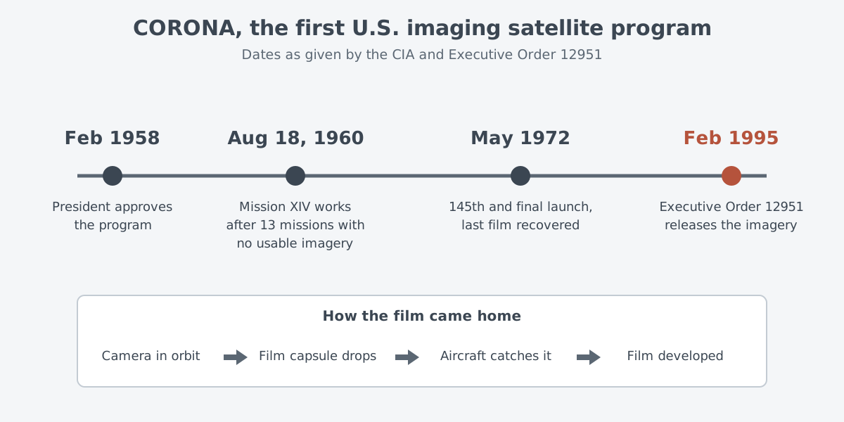
What did these pictures change? Within a few months, CIA photo interpreters had put to rest the so-called "missile gap" and "bomber gap." According to the CIA, the images showed that the Soviet Union was in fact well behind the United States in building a working intercontinental ballistic missile (ICBM).
The pictures mattered for arms control as well. The CIA says CORONA let the United States agree on terms with the Soviet Union that could be checked, in the Strategic Arms Limitation Treaty (SALT). Satellite imagery became the core of U.S. arms-control verification.
Over the program's life, the Defense Department used the imagery to make military maps of areas it could not enter, more accurately than before. In that time, CORONA collected more than 800,000 images.
Optical and radar satellites
Gathering information from a distance is called remote sensing. Instruments on satellites detect and record energy that the surface reflects or gives off. They fall into two groups, depending on where that energy comes from.
A passive instrument only receives energy that comes from the natural environment. Optical imagery works this way. It gathers visible light along with near-infrared and short-wave infrared light. CORONA, which recorded light on film, belongs to this group.
An active instrument sends out its own energy and builds its data from changes in the returning signal. Synthetic aperture radar (SAR) is one of them. It sends a pulse of energy and records how much of it bounces back after hitting the surface.
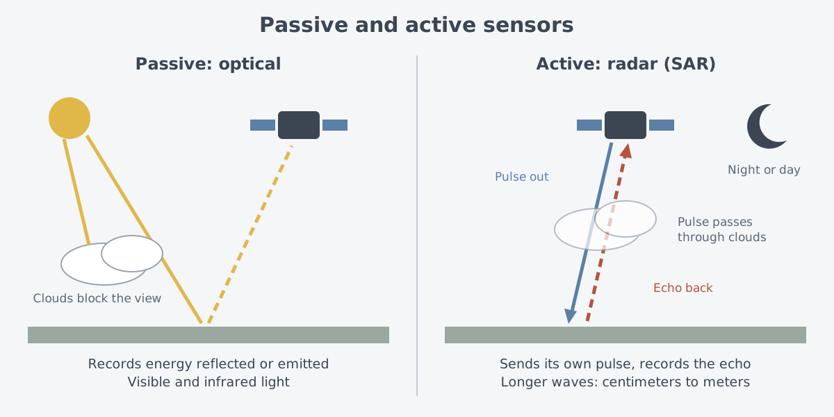
Picture shouting in a dark valley and listening for the echo, and you have the idea of an active sensor. In reality, radar receives returning radio energy rather than sound, and the image is built from how much of it comes back. The basics of radar are in "Radar: measuring distance and motion with radio waves."
The two kinds differ in use. Radar uses longer wavelengths, from centimeters to meters, so it can image ground covered by clouds or hidden under a thick forest canopy. NASA, the U.S. space agency, says SAR can produce images night or day, whatever the weather.
The words "synthetic aperture" come from a problem with antenna size. At a given wavelength, a longer antenna gives higher spatial resolution, but an antenna that long cannot be carried by a satellite in space. So a smaller antenna takes a series of measurements, and these are merged to behave like a far bigger one. The full principle is in "Synthetic aperture radar: images from radio waves."
Orbits and revisits
Orbits follow the same physics whatever job a satellite does. This section uses examples that NASA has published for its science and weather satellites. Earth orbits fall into three broad types: low, medium and high.
The closer a satellite is to Earth, the stronger the pull of gravity and the faster the satellite moves. At the high end sits the geostationary orbit. About 36,000 km above the surface, a satellite's trip around Earth matches Earth's rotation, and a geostationary satellite over the equator stays right above the same spot. Because it can watch the same area without a break, this orbit is valuable for weather monitoring.
A low orbit is much closer to the surface. Many NASA Earth-observing satellites fly a nearly polar orbit and take about 99 minutes per trip around the planet. Earth turns underneath during that time. So when the satellite returns to the sunlit side, it passes above the neighboring area rather than the one it saw last time.
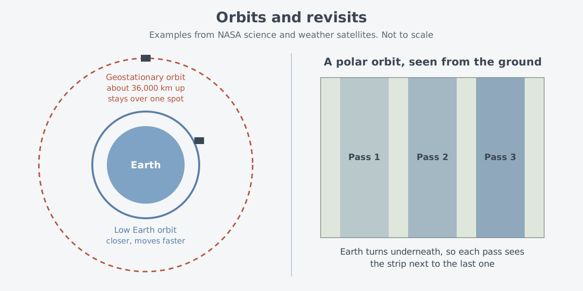
It looks a little like a lawn mower covering a yard one strip at a time. In reality, the satellite does not step sideways; Earth turns beneath it and brings the next strip into view. In 24 hours, a polar-orbiting satellite covers most of the planet two times: one pass on the day side and one on the night side.
The time a satellite takes to come around and see the same area again is called temporal resolution. Three things set it: the orbit, the instrument, and the swath, meaning the width of ground covered in one pass. A satellite in low orbit sees from close up but cannot stay over one place, while a geostationary satellite watches one place all the time but from far away.
Science missions also use a Sun-synchronous orbit. The satellite crosses the equator at about the same local time every day, so sunlight strikes the ground at a fairly steady angle. Pictures from one season can then be set against pictures from that same season years later, with less worry that big shifts in shadow and light will mislead.
Which orbit to use depends on what the satellite is meant to watch. Even the tilt of the orbit, its inclination, is chosen to fit the job the satellite was sent up to do. Low orbits come at a price, too. Even the thinnest layer of the atmosphere creates drag, which slowly pulls satellites out of their orbits.
When the pictures were declassified
CORONA's pictures stayed secret for decades. On February 22, 1995, President Clinton signed Executive Order 12951, and on February 24 Vice President Gore announced it at CIA Headquarters.
The core of the order is short. Imagery from CORONA, ARGON and LANYARD was to be declassified within 18 months. It would then go to the National Archives and Records Administration (NARA), and the U.S. Geological Survey (USGS) would get a copy. Once transferred, the imagery counted as declassified and open to the public.
Why release it? According to USGS, an Environmental Task Force in 1992 looked at whether early satellite data could serve environmental studies. By then the data no longer mattered much for national security, and they might hold historical worth for research on global change.
In his announcement, Gore said satellite coverage had given the country the confidence to seek arms control deals. He added that the satellites captured far more than Cold War scenery. They kept a record of how Earth's environment looked for later generations, ten or more years before any nation put up an Earth resources satellite.
USGS counts upward of 860,000 ground images from the three programs, taken from 1960 to 1972. The images were first used for reconnaissance and for maps made for U.S. intelligence agencies. Files that have already been digitized can be searched and downloaded at no cost through the USGS EarthExplorer tool.
Not all reconnaissance imagery was released. The same order kept imagery from all other systems secret until the Director of Central Intelligence (DCI) decided otherwise. It also called for a plan to review that imagery on a regular schedule.
Where this meets lasers: sensors that send their own signal
The active approach of radar satellites has a laser counterpart. Lidar (Light Detection and Ranging) measures distances to the Earth with pulses of laser light, and it is one form of remote sensing. It sends laser light instead of radio waves and reads the signal that comes back, which puts it in the same group as the active instruments above.
How the round-trip time of light gives a distance is explained in "Measuring with lasers: range finding and lidar basics." The only difference is whether the signal is radio or laser light. Read the two articles side by side and the same frame appears: send your own signal, then read what comes back.
What to read next
- "Synthetic aperture radar: images from radio waves": a closer look at the "synthetic aperture" this article only touched on.
- Early-warning satellites: spotting launches from space: satellites that watch for signs of a launch rather than taking pictures.
- "Radar: measuring distance and motion with radio waves": the basic principle that radar satellites rely on.
- "ISR drones: why endurance matters": gathering information by staying aloft for a long time in the sky rather than in orbit.