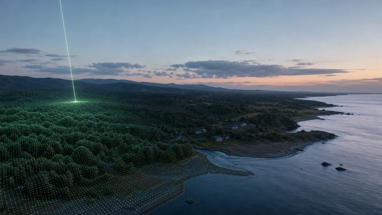
A map app lets you spin a city block in 3D. Foresters measure tree heights, and coastal surveyors compare how a shoreline has moved. One way to make this kind of data is to fire a laser from the sky. Lasers cut and weld, but they also measure.
How does light measure a distance? Why should the pulse be short? How does one distance become a 3D map? This article follows those questions in order.
The round-trip time of light
Shout at a cliff and an echo comes back a moment later. The longer the wait, the farther away the cliff is. Laser ranging starts from the same idea, but it uses short bursts of light instead of sound. The real difference is that light is far faster than sound, so the time has to be measured in billionths of a second.
A pulsed laser fires a pulse toward an object. The pulse hits the object, and part of it reflects back to a sensor next to the laser. The device times the interval from firing to the return. Because this is the time the light spends flying, it is called the time of flight.
That interval covers the trip out and the trip back. So the time is cut in half when the distance is worked out.
distance = speed of light × round-trip time ÷ 2
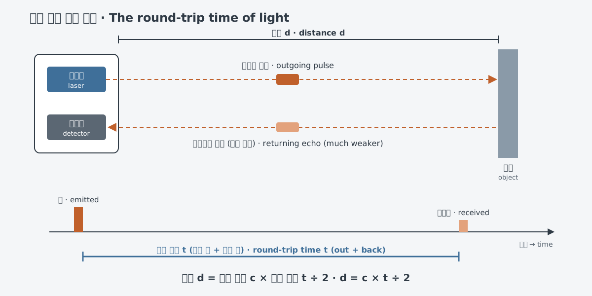
Airborne survey lidar (LiDAR) follows exactly these steps. A technical note from the laser optics company Newport says the recorded time is divided by two and multiplied by the speed of the light pulse, about 3 × 10⁸ m/s. Most commercial airborne lidar sensors are based on this pulse round-trip timing.
Radar measures distance with radio waves in the same way. Lidar is an active remote sensing technique similar to radar, except that it uses laser pulses instead of radio waves. The radar side of the story is in Radar: measuring distance and motion with radio waves.
The speed of light as a ruler
In the formula, the speed of light plays the part of the ruler. The speed of light in vacuum is 299 792 458 m/s. The constants table of the U.S. National Institute of Standards and Technology (NIST) lists its uncertainty as "exact."
Why does the speed of light carry no error? The International Bureau of Weights and Measures (BIPM) defines the International System of Units (SI) through seven defining constants, and the speed of light is one of them. Each value is fixed exactly, and the units follow from it. So one metre is the length of the path light travels in vacuum in 1/299 792 458 of a second.
Measuring distance with light fits naturally, since the unit of length already rests on the speed of light. What remains is how finely the time can be measured. A few calculations make this concrete.
| Round-trip time | Distance (calculated with the speed of light) | Where the number comes from |
|---|---|---|
| 1 ns (a billionth of a second) | about 15 cm | worked example |
| 1 µs (a millionth of a second) | about 150 m | worked example |
| about 3.3 ms | about 495 km | round-trip time of NASA's ICESat-2 satellite |
| about 2.6 s | 385,000 km | the average Earth–Moon distance (1994 article), worked backward |
What does 15 cm for a 1 ns round trip mean? To know a distance to the centimeter, the time has to be split finer than a billionth of a second.
Light slows down a little in air or glass. Its speed inside a material is the speed in vacuum divided by the material's refractive index. For measurements in air, the speed of light in vacuum serves as a good approximation.
What the pulse duration decides
The time one pulse lasts is called the pulse duration. It is measured as the full width at half maximum (FWHM), the time between the two points where the pulse intensity is half its highest value. Airborne lidar pulses typically last a few ns. The basic pulse quantities are covered in Continuous-wave and pulsed lasers.
Pulse duration decides whether two objects close together can be told apart. With a long pulse, the echo from the front object and the echo from the back object overlap in time. The detector receives them as a single lump. With a short pulse, the two echoes separate and show up on their own.
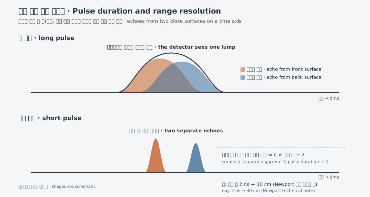
There is a formula for this. The smallest gap that can be resolved is the speed of light times the pulse duration, divided by two. A 2 ns pulse gives 30 cm, so two objects must be farther apart than that to be identified as separate targets. A Newport technical note gives lidar sensor pulse durations of 2–5 ns, limited mainly by the bandwidth of the receiver.
That 30 cm is the resolution. It is the ability to separate two objects, which is not the same thing as accuracy, meaning how correctly the distance to one object is measured. Lunar ranging, covered below, measures the distance to a single reflector, and the 1994 article gives its accuracy as about 3 cm.
Lidar: from distances to maps
Measuring one distance makes a range finder. Lidar repeats that measurement rapidly while it changes the beam direction, covering a wide area with points. The name stands for Light Detection and Ranging. The U.S. National Oceanic and Atmospheric Administration (NOAA) describes lidar as a remote sensing method that uses pulsed laser light to measure ranges.
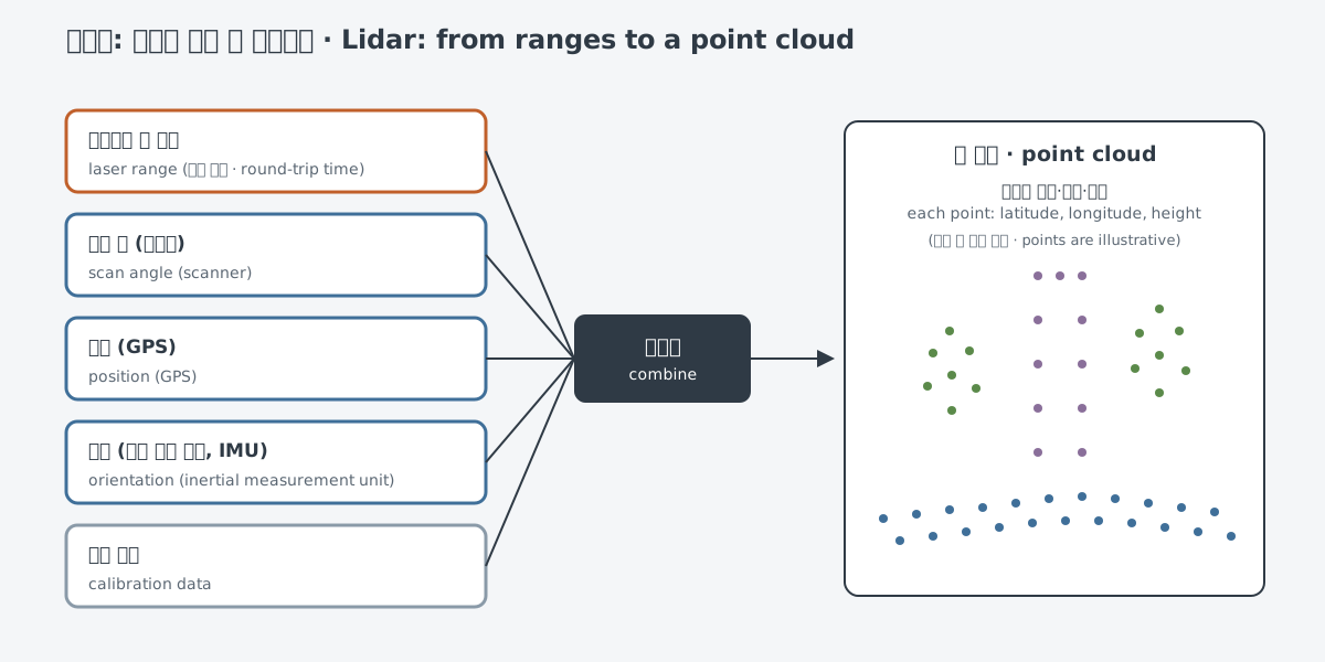
The main parts of a lidar instrument are a laser, a scanner and a specialized GPS receiver. Laser ranges are combined with position and orientation data from GPS and an inertial measurement unit (IMU), scan angles and calibration data. The result is a point cloud. Each point carries a latitude, longitude and height, so together the points form the 3D shape of the ground, trees and buildings.
How fast the points are recorded depends on the laser's pulses. The pulse repetition rate and pulse energy set the sampling rate of a lidar system. Early commercial units worked at 10 kHz, or 10,000 points per second, and newer systems can exceed a pulse rate of 1 MHz.
One pulse does not always end with one echo. If leaves reflect only part of it and the rest travels on to lower objects and reflects again, several echoes come back. Systems that record these multiple returns map 3D structures such as forest canopies and individual tree crowns better. Industry material names the vertical structure of forests as something lidar is uniquely able to measure.
The wavelength is chosen as well. Topographic lidar, which maps the land, typically uses a near-infrared laser, while bathymetric lidar, which also measures seafloor and riverbed elevations, uses green light that passes through water. Industry material lists three wavelength regions: 1064 nm, 532 nm and 1550 nm. Each has trade-offs, weighed against target reflectance and absorbance, background light, atmospheric transmission and eye-safety issues.
The uses are broad. NOAA notes that lidar data supports work such as flooding and storm surge modeling, shoreline mapping, emergency response and hydrographic surveying. Lidar has also helped find ancient Roman roads in northern England and Maya cities hidden under the jungles of northern Guatemala.
Measuring from orbit and to the Moon
NASA's ICESat-2 satellite carries a single instrument, ATLAS. ATLAS times laser pulses on their way down and back to calculate the distance between the spacecraft and Earth's surface. Its light is green at 532 nm, and it fires 10,000 pulses per second. The first ICESat satellite fired 40 per second.
The round trip takes about 3.3 ms. Calculated as in the table above, that is about 495 km, which matches the 310-mile altitude (about 499 km) that NASA lists.
The instrument measures the distance from itself to the ground. So the satellite's altitude must be known precisely for the ground heights to come out right. Where the measuring device sits matters as much as the distance it measures.
Lasers also reach the Moon. In 1969 the Apollo 11 crew left a laser ranging retroreflector array on the lunar surface. It is made of 100 pieces of fused silica called corner cubes, and corner cubes send light straight back toward where it came from. Because a pulse fired from Earth returns to its starting point, its round-trip time can be measured.
According to a 1994 article carried on a NASA site, this method set the Earth–Moon distance to an accuracy of about 3 cm. The average distance between the two centers is 385,000 km. Calculated from that distance, a round trip takes light about 2.6 seconds, and because it is a center-to-center distance, the real round trip is a little shorter. The same measurements showed that the Moon is moving away from Earth by about 3.8 cm a year.
The hard parts and other methods
First, very little light comes back. Each ICESat-2 pulse sends out about 300 trillion photons, but only about a dozen return to the satellite's telescope. In lunar ranging, even in good atmospheric conditions, one photon came back every few seconds (1994 article).
Sunlight gets in the way too. Sunlight reflected off Earth can swamp the detectors. ICESat-2 blocks it with filters that pass only 532 nm light.
How far a system can measure also depends on several conditions. Newport lists the laser peak power, the reflectance of the target surface and the ambient light coming from the target. The reflected light must be strong enough to rise above the detector's noise before the detector registers the pulse.
Time of flight is not the only way to measure distance with light. Experiments have shown precise ranging with dual-comb lasers, which produce two pulse trains with different repetition rates. Inside optical fiber, a method called OTDR measures the reflections and backscatter that come back.
What to read next
- Radar: measuring distance and motion with radio waves: the same round-trip principle, with radio waves instead of light.
- Why lasers are studied by calculation first: why lasers are examined by calculation before experiments.