When a rocket leaves the launch pad, a blinding flame pours out of its tail. That flame gives off more than light. It also releases a great deal of heat, and that heat spreads out as light the eye cannot see: infrared.
Could that heat be seen from very far away, from beyond the Earth itself? Early-warning satellites grew out of that question. This article looks at what infrared is, why it is watched from space rather than from the ground, and how U.S. early-warning satellites developed, using public sources.
Light you feel as heat
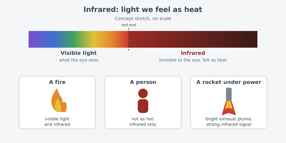
Infrared is one part of the electromagnetic spectrum. Your eyes cannot see it, but your skin feels it as heat. It has a longer wavelength than visible light, so it sits just past the red end of the rainbow.
This light was first found in 1800. According to NASA, William Herschel placed thermometers in each color of visible light and measured the temperature differences. The temperature rose from blue toward red, and just past the red end it was higher still. Light the eye could not see was there.
Very hot objects, such as a fire, give off both visible light and infrared. Objects that are not as hot, such as people, give off only infrared. That is why an instrument such as an infrared camera can show the heat of people and animals as a picture.
Satellites already watch the Earth in infrared. Instruments on Earth observation satellites measure the infrared given off by land and sea to follow changes in surface temperature. On the U.S. Aqua and Terra satellites, an instrument called MODIS relies on infrared data to watch smoke and pinpoint where forest fires are burning.
A missile driven by a rocket is no different. A missile shows a bright exhaust plume signature while it is under power. The idea of finding missiles by this heat is fairly old.
The National Security Archive at George Washington University has collected declassified documents on this history, with commentary. According to that archive, by 1948 scientists in U.S. government service were already studying whether launch heat and plume infrared could reveal and track missiles.
In 1955, a RAND Corporation study caught the attention of several science advisory committees. It focused on the heat an intercontinental ballistic missile gives off at takeoff and on reentry into the atmosphere, and on the fact that hot metal gives off infrared well. It pointed out the limits of detection from the air and suggested that detection from satellites might be feasible.
Why look from space, not the ground
Because the Earth is round, a radar on the ground has trouble seeing past its horizon. SBIRS is the U.S. early-warning satellite system in use today, covered in more detail later. A National Research Council report says it is usually the first sensor to detect and track a missile. That is especially true for missiles launched deep inside a country, out past where any radar can see.
The higher you go, the more you can see. A Congressional Research Service (CRS) report quotes the 2019 U.S. Missile Defense Review, which points out that space sensors make use of the wide area visible from orbit.
It is a bit like a watchtower on a hilltop, which sees farther than a village below. The real case is different in one way. A guard in the tower spots smoke and firelight by eye, but a satellite must pick out a missile's heat against the heat of the Earth's surface and clouds.
The choice of orbit matters too. A satellite in geostationary orbit turns with the Earth, right over the equator, so it stays above the same spot. It can watch the same area without a break. But because it sits over the equator, the far north and far south are always at the edge of its view.
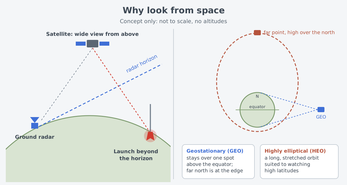
Watching high latitudes calls for another orbit. The Molniya orbit, a long and stretched ellipse, is well suited to watching high latitudes. The U.S. SBIRS also places satellites and hosted sensors in two kinds of orbit: geostationary (GEO) and highly elliptical (HEO).
MIDAS: the first tries from orbit
The history from MIDAS to the DSP follow-on programs also follows that archive. The first steps came in the late 1950s. By early November 1958, one part of a U.S. satellite program had been named MIDAS, the Missile Defense Alarm System.
The tests did not go smoothly. MIDAS 1, launched on February 26, 1960, never separated from its booster and fell into the Atlantic Ocean. MIDAS-2 reached orbit on May 24 of the same year, but its communication link failed, so it sent infrared data to the ground for only a very short time.
The idea was clearly proven only with MIDAS 7, launched on May 9, 1963. This satellite detected missile launches that had been scheduled as a test for it. Even so, the program did not go straight to an operational system. Questions about cost, and about what a warning satellite should be able to do, were still open.
From DSP to SBIRS
The program to build an operational constellation went through several names before it became the Defense Support Program (DSP). DSP satellites were to go into geostationary orbit. The first one, launched on November 5, 1970, did not reach its proper orbit, but the second one did.
DSP came to serve more purposes than first planned. It also detected and gave intelligence on missiles fired in conflicts within a region, including the Iran–Iraq War of 1980–1988 and the 1991 Persian Gulf War.
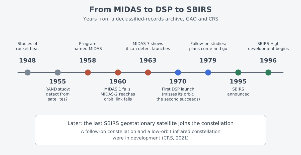
Work on a successor to DSP began as early as 1979. But a real follow-on program took a long time to settle, and only in 1995 did the Air Force announce SBIRS, the Space-Based Infrared System. In a 2010 report, the U.S. Government Accountability Office (GAO) described SBIRS High as the planned replacement for DSP, with system development starting in 1996.
Its maker, Lockheed Martin, presents SBIRS as a system that uses infrared surveillance to give the U.S. military early missile warning. Satellites and hosted sensors in geostationary and highly elliptical orbits, plus ground equipment and software, make up one system. The last geostationary satellite in the SBIRS series has already joined the U.S. Space Force constellation of missile warning satellites.
The next generation is also on the way. According to a 2021 report by the Congressional Research Service (CRS), the U.S. Space Force was working on a constellation to follow SBIRS. Separately, the Space Development Agency (SDA) was building a constellation in low Earth orbit to detect hypersonic missiles, using infrared technology similar to SBIRS.
What made it hard
The principle of watching heat is simple, but doing it reliably from space was hard from the start. In the MIDAS years, some feared that problems such as background radiance and clutter from clouds would keep anyone from building a working system. Some people in the Air Force and at contractors felt more hopeful.
The road to a successor was long as well. Debates and disagreements over cost and technical requirements meant that a string of DSP follow-on programs were proposed and then cancelled over more than fifteen years. Even after SBIRS was announced, trouble with the infrared sensors meant for the high-orbit satellites, schedule slips and large rises in expected cost pushed back the first launch.
GAO's 2010 assessment is more specific. When SBIRS High began development in 1996, not one of its three key technologies was mature: the infrared sensor, on-board processing and thermal management. Flight software design problems also drove up costs and caused delays for several years.
Where this meets lasers: eyes that read heat
The idea of finding a powered missile by its infrared heat also appears in the history of laser weapons. A National Research Council report explains that the Airborne Laser (ABL) concept used infrared sensors on the aircraft to find the exhaust plume of a boosting missile and identify threats. What the ABL program was, and why it ended, is covered in A history of laser weapons.
Early-warning satellites share a basis with infrared search and track (IRST) equipment on aircraft: both find their target by receiving the infrared it gives off on its own. One looks down on the Earth from space, and the other scans the sky from an aircraft.
What to read next
- Reconnaissance satellites: information from orbit: optical and radar satellites, and the ideas of orbit and revisit.
- Infrared search and track: seeing aircraft without emitting: how the same infrared is used in the sky.
- A history of laser weapons: from chemical to electric lasers: the path the Airborne Laser (ABL) took.
- Ballistic missiles: why they climb high and come down: the flight phases of the missiles that early-warning satellites watch.