How does a ship in the middle of the Pacific join the same command network as a unit in a distant desert? Ground radios cannot do it alone. The round Earth bulges up between them.
For decades, military satellite communications have filled that gap. For a long time the job fell to a few large satellites in a very high orbit. Now the weight is shifting toward hundreds of satellites in low orbit.
Talking past the horizon
For many ground radios, the curve of the Earth sets the limit: they reach only as far as a straight line of sight allows. A Congressional Research Service (CRS) report notes that ground radios usually work at short ranges of no more than 50 miles. Longer links mostly go through satellites.
For decades the military has relied mainly on satellites for beyond-line-of-sight (BLOS) traffic. The uses are broad. Everything from data sent by unmanned aircraft to signals built to hold up for nuclear command, control and communications passes through satellites.
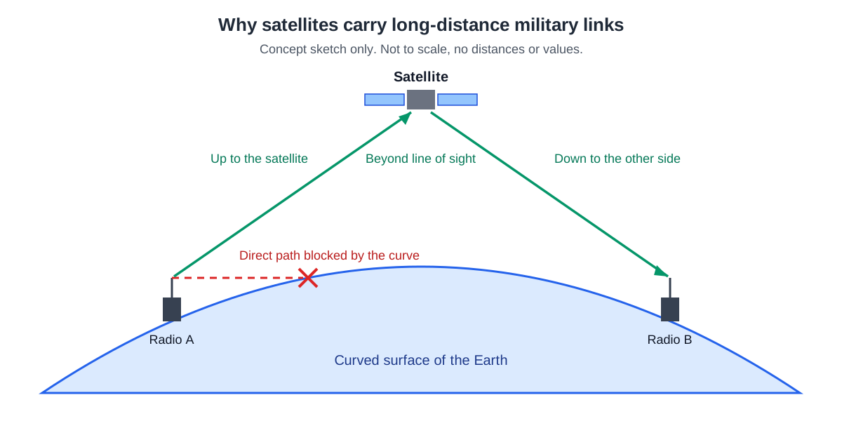
A satellite works a bit like a relay tower on top of a very tall mountain. The real thing is different. A satellite is not fixed to the ground; it moves in orbit, and the signal climbs that long distance and comes back down at the speed of light. That trip adds latency, a time delay, to every satellite link.
High satellites and low satellites
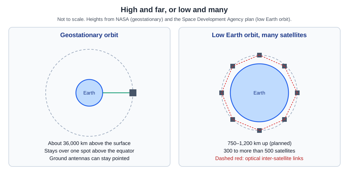
At about 36,000 km above the surface, a satellite circles the Earth at the same rate the Earth turns. This is called a geosynchronous orbit. A satellite on a circular geosynchronous orbit directly above the equator does not move at all as seen from the ground. That special case is a geostationary orbit.
Because it always stays in the same place, it suits communications. A ground antenna does not have to chase the satellite; it can stay pointed in one direction. In practice, most communications satellites sit in geosynchronous orbit.
There are limits. A geostationary satellite stays over the equator, so places far to the north or south always see it at the edge of their view. And the higher the satellite, the longer the path the signal travels up and down.
Low Earth orbit (LEO) begins just past the upper edge of the atmosphere. The lower the orbit, the faster a satellite moves, and an Earth-observing satellite on a pole-to-pole orbit takes about 99 minutes per lap. To keep every ground terminal always in touch with some satellite, a large number of satellites must go into low orbit.
The main strands of U.S. military satcom
CRS names three global satcom constellations operated by the U.S. military. WGS is the wideband system, AEHF is the protected system, and MUOS, the Mobile User Objective System, is aimed at mobile users, as its name says.
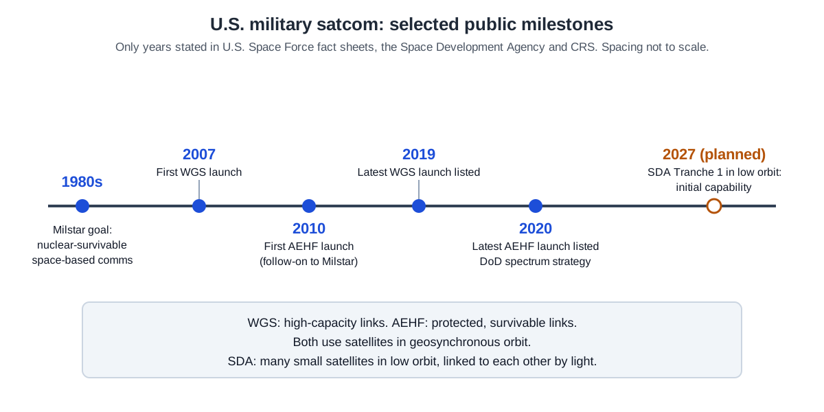
A U.S. Space Force fact sheet calls WGS (Wideband Global SATCOM) the backbone of U.S. military wideband satcom. It serves not only U.S. government agencies and the Department of Defense but also several international partners and NATO. Its satellites are in geosynchronous orbit, and the system has three parts: satellites, control and user terminals. The first launch was in 2007, and the last launch listed in the fact sheet was in 2019.
AEHF (Advanced Extremely High Frequency) has a different focus. In the words of its fact sheet, it gives high-priority ground, sea and air forces communications that are survivable, secure, protected and jam-resistant. Its satellites are also in geosynchronous orbit, and it covers the area between the north and south poles 24 hours a day. The first launch was in 2010, and the last one listed was in 2020.
The generation before AEHF was Milstar. The aim of the Milstar program was a global, secure space-based communication system that could survive a nuclear environment. In the 1980s, under the Reagan administration, it was seen as a top national priority. Its satellites were designed to handle the communication processing and network routing on board, so vulnerable relay stations on land were no longer needed.
The military does not rely only on its own satellites. The Department of Defense also uses commercial satellites for communications. Part of the reason is that bandwidth on its own satellites is limited. How many satellites are up, how much data each can carry and how much area each covers all have limits.
The move to many satellites in low orbit
The Space Development Agency (SDA) takes another path. Its design puts many satellites, possibly hundreds or thousands, below 2,000 km. SDA calls this pLEO, for proliferated low Earth orbit. That runs opposite to many current military space systems, which sit farther out, in geosynchronous orbit or medium Earth orbit (MEO).
Why launch so many? With many small satellites, the disruption or defeat of a few does not take the capability down. The satellites are linked into a mesh, so the network keeps running when one drops out. Each satellite is also smaller and cheaper than some of the costly defense space assets fielded in small numbers, and it can be built and replaced faster.
Low orbit has its own benefits as well. Putting a satellite there costs less than reaching a higher orbit, and links to the ground have lower latency and need less power. In SDA's view, these benefits are why commercial firms have also started offering communications through LEO constellations.
The SDA Transport Layer is planned as a low-orbit constellation at 750–1,200 km, with anywhere from 300 to over 500 satellites. Once the full constellation is up, the plan is for at least one satellite to be in view from 99% of locations on Earth at any time.
The work moves in generations, called tranches, which SDA delivers every two years.
Tranche 1 launches are still under way. According to an SDA announcement in October 2026, once the fourth orbital plane went up, the number of Tranche 1 satellites in orbit reached 84. When complete, Tranche 1 will have 154 operating satellites, 126 of them in the Transport Layer. SDA says Tranche 1 is planned to deliver its first capability starting in 2027.
A crowded and contested spectrum
Satellite links still use radio waves. The range of radio frequencies that wireless technology uses is called the spectrum. Two kinds of pressure act on it at the same time.
One is civilian demand. In its 2013 electromagnetic spectrum strategy, the Department of Defense used the word "congestion" for the growing commercial demand for spectrum. The other is competition. The 2017 electronic warfare strategy used the word "contested" for potential adversaries building systems meant to challenge the U.S. lead in the spectrum.
The Electromagnetic Spectrum Superiority Strategy, released in October 2020, brought the two ideas into one document. Its direction is to meet commercial demand while still supporting operations in a contested environment. The wider contest over the spectrum is covered in Electronic warfare.
Where this meets lasers: light between satellites
Satellites in the SDA Transport Layer talk to each other with light rather than radio waves. These connections are called optical inter-satellite links (OISLs), and SDA describes them as performing far better than the radio crosslinks used so far.
The Department of Defense has been testing several laser communication systems to raise data rates and to make it harder for an adversary to jam its links. Relaying data between satellites is one of those uses. CRS points out that the narrow laser beam greatly lowers the risk of jamming or disruption on point-to-point links between satellites.
A narrow beam comes up again and again in articles on laser weapons too. One carries data and the other carries energy, so the goals differ, but both face the same question of how much light spreads over a long distance. That question continues in Why a beam spreads.
What to read next
- Electronic warfare: the invisible contest: the whole contest over the spectrum.
- Inertial and satellite navigation: knowing where you are: satellites that give position and time instead of carrying messages.
- Jamming and spoofing: interference versus deception: what it means to block or fake a satellite signal, as a concept.
- Why a beam spreads: divergence, focus and aperture: the physics behind the narrow beams that laser links between satellites depend on.