A helicopter passes slowly over a forest. From above, all you can see is leaves. Yet when the data is processed later, the rise and fall of the ground shows up as countless dots, as if the trees had been lifted away.
The device that places those dots is lidar. The military has used it to build 3D maps of wide areas, to look under leaves and camouflage, and to measure the seafloor and the water just below the surface. This article covers what lidar measures, how public military research and agency programs built on it, and where it runs into limits.
Radar's cousin that uses light
Lidar, short for light detection and ranging, measures distance from afar with pulses of laser light. It is also written LiDAR, and military research papers often call it LADAR or ladar. Its job is much like radar's, but it sends short pulses of laser light instead of radio waves.
Lidar sends out its own light and catches the reflection. A camera depends on sunlight, but lidar is an active sensor, so it can work after dark, when the air is generally clearer and fewer aircraft are flying. The U.S. National Oceanic and Atmospheric Administration (NOAA) guide Lidar 101 notes that most lidar data are in fact collected at night.
The basis of the distance measurement is the time light takes to go out and come back. How the round trip and the pulse duration set the distance is covered in Measuring with lasers: range finding and lidar basics. Here the question is how each of those distances becomes part of a map.
From a cloud of points to a map
What lidar first gets is a single distance. Two more things are needed before that distance becomes a point on the ground: the angle the pulse was sent at, and where the sensor was at that moment.
On an aircraft, GPS gives the position, and an inertial measurement unit (IMU) gives the tilt and heading. Put the time difference, the angle and the sensor position together, and each point gets a latitude, a longitude and a height. A huge collection of such points is called a point cloud.
It is a bit like learning the shape of a dark room by tapping around with a long stick. The real thing uses light instead of a stick, taps far more often than any hand could, and records its own position and the stick's direction with every tap. Only after the point cloud is turned into elevation models of the ground, models of tree canopies and buildings, and contour lines does it become a map people can use.
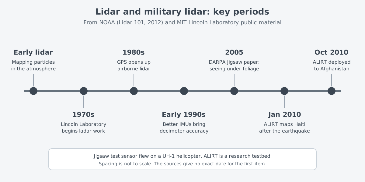
This method did not start in the sky. Lidar was first used to map particles in the atmosphere, and in the 1980s GPS opened it up to moving sensors, meaning airborne lidar. In the early 1990s better IMUs let it begin reaching accuracy of about 10 cm, the decimeter level.
Seeing the ground between the leaves
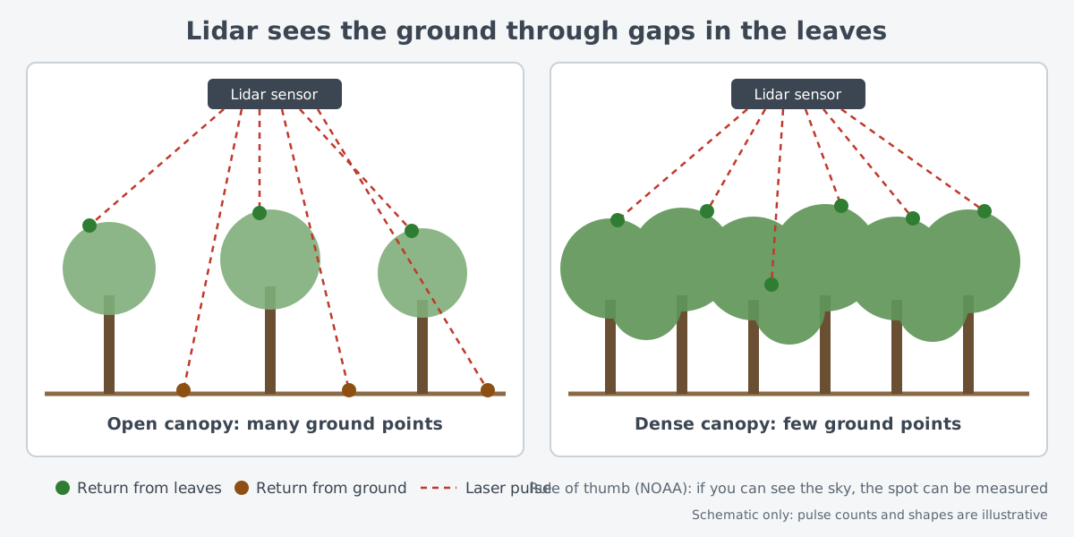
Lidar cannot pass through leaves either. It can still map the ground under a forest because it sends so many pulses. Even if only a small share of them slip through gaps to the ground, there are usually enough ground points to cover the forest.
The NOAA guide offers a simple rule of thumb. If you can stand under the trees and see the sky, that spot can be measured with lidar. In a forest with almost no openings, such as a rain forest, nearly all the points land on treetops and mid-canopy leaves, and few reach the ground.
In military research, this property was set beside radar. Ground vehicles can be found and imaged with microwave radar from aircraft or satellites, but camouflage nets and tree foliage can degrade that radar. Microwaves with a long wavelength can get through leaves, but usually at the cost of image resolution. A 2005 paper by MIT Lincoln Laboratory in the Lincoln Laboratory Journal on the DARPA Jigsaw program starts from this problem.
The public goal of Jigsaw was a high-resolution imaging lidar that could map, from the air and in 3D, military ground vehicles hidden under camouflage or foliage, and identify them. The laboratory's test sensor was fitted to a UH-1 helicopter, worked day or night, and built 3D images from short laser pulses. Other uses listed for the technology were robot vision, navigation for autonomous vehicles, manufacturing quality control and terrain mapping.
Wide areas at once: a research testbed and disaster maps
Lincoln Laboratory has worked on high-resolution ladar since the 1970s. Small solid-state microchip lasers, together with efficient Geiger-mode avalanche photodiode (APD) arrays made its sensors small and rugged. One result is the Airborne Ladar Imaging Research Testbed, or ALIRT.
ALIRT measures a patch of the scene with each pulse rather than a single point. A short laser pulse lights up a wide area of ground at once. Some of the scattered light returns, and each part of the scene falls on its own pixel of the detector array. Each pixel times its own returning light, so the result is a range image instead of the brightness image a camera makes.
To place that range image on a map, the position and attitude data described above are needed. In ALIRT, a GPS/IMU supplies the receiver's location and orientation, and a scanning mirror sweeps the telescope's view quickly across a wide scene. The laboratory says the testbed has many military and civilian uses.
The main uses of ALIRT were put on show in relief operations after the January 2010 earthquake in Haiti. The laboratory's tech note says 49 flights over 30 days gathered data for surface models covering most of the quake-hit capital, Port-au-Prince.
The maps helped find helicopter landing zones and judge whether roads and bridges were passable. They also helped share out food and water by watching how displaced-persons camps changed, and pick sites for temporary housing through flood-plain analysis. The military agency leading the response was U.S. Southern Command (USSOUTHCOM).
The 2011 R&D 100 award announcement also records that ALIRT was deployed to Afghanistan from October 2010 and gathered imagery over more than 150 flights. The uses it lists include finding objects hidden by foliage or camouflage, tracking changes in terrain, and building country-sized reference maps.
Lidar over the sea
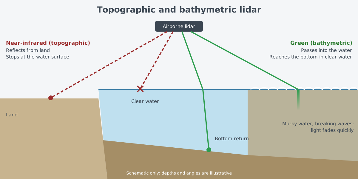
Topographic lidar, which maps land, usually uses a near-infrared laser. Because of its wavelength, this light cannot get through the water surface. Bathymetric lidar, which maps underwater, uses green light that passes into water, so it can also measure the height of seafloors and riverbeds. According to the NOAA guide, bathymetric lidar was among the earliest jobs given to airborne lidar.
One center does this work jointly for military and civilian agencies. The Joint Airborne Lidar Bathymetry Technical Center of Expertise (JALBTCX) runs airborne lidar bathymetry, along with research and development. Its work supports coastal mapping and charting for the U.S. Army Corps of Engineers (USACE), the U.S. Naval Meteorology and Oceanography Command and NOAA. Its staff are drawn from NOAA's National Geodetic Survey, the Naval Oceanographic Office, and two USACE bodies: the Mobile District and the research and development center known as ERDC.
Lidar is also used to look for hazards in the water near the surface. The AN/AES-1 Airborne Laser Mine Detection System (ALMDS) is carried on the MH-60S helicopter. Its mission is to detect, classify and locate mines that float or are moored near the surface.
As the maker, Northrop Grumman, describes it, a pulsed laser and streak tube receivers in an external pod image the water near the surface. The system works day or night without towing anything through the water. It is also part of the mine countermeasures mission package of the Littoral Combat Ship (LCS).
Clouds and murky water
Lidar needs a clear sky. The NOAA guide says that unlike radar, lidar cannot get through clouds, rain or dense haze, so it has to be flown in fair weather. Seeing through clouds is left to radar, which uses radio waves. Why light weakens and scatters in air is covered separately in Light through air: absorption, scattering, turbulence, thermal blooming.
The water has to be clear as well. Bathymetric lidar can measure the bottom in fairly clear water, but in very murky water or breaking waves the light reaches only a few feet or less. Where waves are strong and the water is cloudy, the data often has large gaps.
The forest needs gaps, too. As shown above, a dense forest gives few ground points. Lidar is not an eye that sees through everything; it is closer to a very fine ruler for places where light has a path to travel and return.
What to read next
- Measuring with lasers: range finding and lidar basics: how the round-trip time and pulse duration set distance and resolution.
- Light through air: absorption, scattering, turbulence, thermal blooming: what laser light goes through on its way through air, seen alongside laser weapons.
- Synthetic aperture radar: images from radio waves: another way to make images of the ground, using radio waves instead of light.