Open a map on your phone and a blue dot marks your spot. Yet no GPS satellite ever says "you are here." All a satellite sends is a short message: its own position right now, and the moment this signal left.
Working out your position is the job of the receiver in your hand. At the center of that work sits a clock. This article follows the steps in order: how time becomes distance, how distance becomes position, who keeps the clocks right, and where the idea came from.
What the satellites send is time
GPS, the Global Positioning System, is a U.S.-owned service for positioning, navigation and timing. In the space segment, a nominal constellation of 24 satellites sends one-way signals that carry each satellite's current position and the time. A receiver picks up these signals and works out its own position in three dimensions, along with the time.
"One-way" matters here. The receiver sends nothing back to the satellites. It only listens. Every satellite repeats its position and the time again and again, and the receiver finds its position by working out how long the signals took to reach it.
When lightning flashes, the later the thunder arrives, the farther away the strike was. GPS also measures distance by "how late did it arrive." In practice two things differ. It uses radio waves moving at light speed instead of sound, and instead of seeing a flash, the receiver reads the departure time written into the signal.
Turning a time gap into a distance
The speed of light in a vacuum is fixed at exactly 299,792,458 m per second. Radio waves move just as fast, so they take about 3.3 µs to cover 1 km. Multiply the gap between the time a signal leaves and the time it arrives by the speed of light, and you get the distance to the satellite.
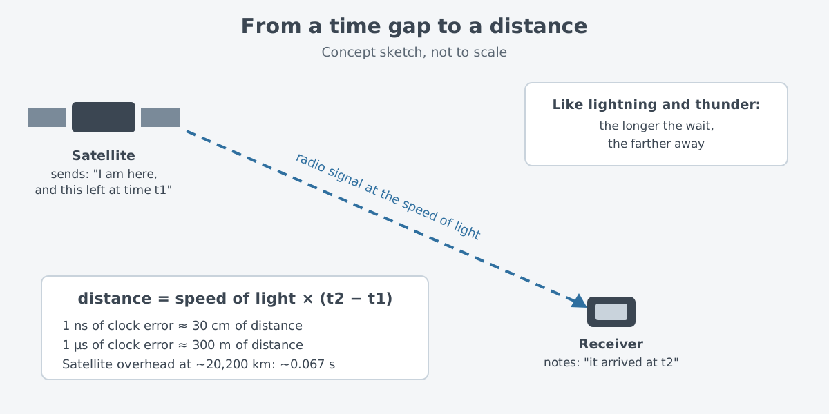
Light is so fast that a small clock error turns into a large distance error. A timing error of 1 ns, one billionth of a second, becomes a position error of about 30 cm. An error of 1 µs, one millionth of a second, shifts the answer by about 300 m.
GPS satellites orbit about 20,200 km up, in what is called medium Earth orbit, and circle the Earth twice a day. For a satellite straight overhead, the signal takes about 0.067 s to come down. A satellite lower in the sky is farther away, so its signal takes a little longer.
Knowing one distance puts the receiver somewhere on the surface of a huge ball centered on that satellite. Knowing the distances to several satellites, the receiver sits where those balls all meet.
Why it takes four satellites
Three distances should be enough to fix a point in space. GPS still needs one more satellite. The reason is the receiver's clock.
The satellites carry atomic clocks. The clock in a receiver, though, is usually a simple oscillator that runs on its own, with noise and drift, and it can be far off. So the time gap multiplied by the speed of light is not the true distance. Because it still contains the receiver's clock error, this value is called a pseudorange.
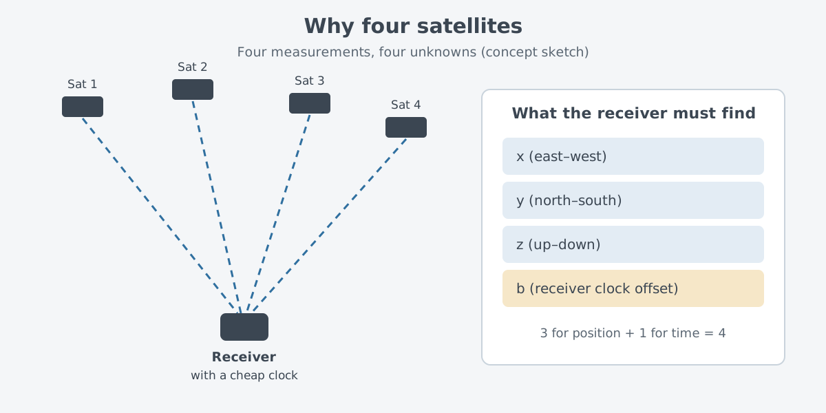
The fix is to treat the clock error as one more unknown and solve for it too. Ashby's 2003 review paper on relativity in GPS explains that a possible receiver clock offset is the reason four satellite measurements are needed. Four measurements pin down the three parts of the position and the clock offset together.
The layout of the satellites is built around this. They sit in six equally spaced orbital planes, so at least four can be seen from almost anywhere on Earth. That is why the costly atomic clocks only need to be on the satellites.
Atomic clocks and relativity on board
Each GPS satellite carries several atomic clocks, and the signals carry very precise time data. The U.S. National Institute of Standards and Technology (NIST) keeps a time and frequency glossary. It notes that each satellite carries a rubidium or cesium atomic clock as the reference for its carrier and code broadcasts. A NASA page also describes today's satellites as each having redundant atomic clocks.
Clocks in orbit face one problem that clocks on the ground do not: the effects described by relativity. Frequency shifts from the relative motion of satellite and receiver, frequency shifts caused by gravity, and an effect from Earth's rotation all reach the clocks. If these are not handled properly, navigation and time transfer end up with unacceptably large errors.
The direction is known. Seen from the ground, a clock in orbit runs too fast, mainly because of gravity. So the satellite clocks are set lower in frequency, with a correction applied before launch so that they keep pace with reference clocks on the ground.
Keeping the clocks in step from the ground
The satellites are in the sky, but the work of looking after them happens on the ground. The control segment is a worldwide network of ground facilities. It tracks the satellites, monitors and analyzes their signals, and sends commands and data up to them.
At its center, the master control station uses data gathered by monitor stations to compute precise satellite positions and build the navigation messages that are uploaded to the satellites. From time to time the control segment sends commands to keep satellites in their proper orbits, and it adjusts the satellite clocks. The satellite clocks are steadily adjusted to match Coordinated Universal Time (UTC) the version kept at the U.S. Naval Observatory (USNO).
This loop holds GPS together. For a satellite to report where it is, the ground has to compute its position and upload it. For it to report the time, the ground has to keep its clock right. The U.S. Space Force builds and runs both the space and control segments.
From Transit to GPS
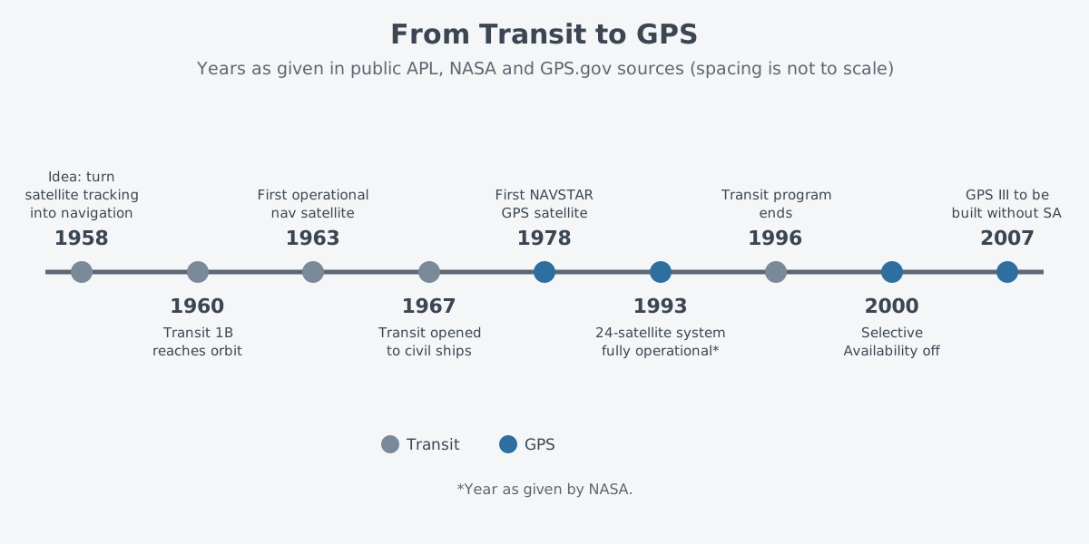
The idea of finding your way by satellite came from solving a problem backward. GPS traces its roots to the Sputnik era. Scientists could track a satellite from the shifts in its radio signal, the Doppler effect, and this became the basic idea behind modern GPS.
At the Johns Hopkins Applied Physics Laboratory (APL), two researchers, Guier and Weiffenbach, were doing this kind of work. They held that a rough orbit could be found from the Doppler data of a single satellite pass. On 17 March 1958, Frank McClure of the laboratory called them in with a question. If the orbit were taken as known, could they work backward to find the position of the station on the ground?
This "inverse problem" later became known as the "navigation problem." At the time, the U.S. Navy was worried about navigating its Polaris submarines, and McClure saw that turning Doppler satellite tracking on its head could solve it. The system that grew from this was Transit, formally the Navy Navigation Satellite System.
On 13 April 1960, Transit 1B went up and became the first Transit satellite to reach orbit. Transit 5BN-2 followed on 5 December 1963, and it was the first navigation satellite put into regular service. In 1967 the system was opened to the public, so ships of any friendly nation could use it, commercial ones included. Transit ran for 32 years, and the program ended on 31 December 1996.
GPS grew up in the meantime. According to NASA, in the early 1970s the Department of Defense wanted a robust and stable satellite navigation system, and in 1978 it launched the first NAVSTAR satellite. The same page gives 1993 as the year the full 24-satellite system came into operation. Where Transit used the Doppler shift of a satellite's signal, GPS uses the time a signal takes to arrive.
Military, civil, and a signal once blurred on purpose
GPS offers one service for civilians and one for the military. Anyone, anywhere, can use the civilian service free of charge, around the clock. The military service is open to the armed forces of the United States and its allies, plus approved government agencies.
For a time, the civilian signal was blurred on purpose: a feature called Selective Availability (SA) lowered the accuracy of public GPS signals for national security reasons. A 1995 National Research Council (NRC) report describes how it worked. The precise time of the clocks on board the satellites was varied on purpose, which put errors into the signal. Back then, civilian accuracy was held to 100 m (95 percent probability).
That shaking a clock was enough to blur a position ties straight back to the start of this article, because time is distance. The United States stopped using SA in May 2000, on President Bill Clinton's order. In September 2007 it announced that future GPS III satellites would be bought without the SA feature.
Today, under open sky, a smartphone using GPS usually lands within 4.9 m of the true spot. Near buildings, bridges and trees, accuracy gets worse. On the military side, new military M code signals with better resistance to jamming, which blocks signals with radio interference, were added starting with the Block IIR-M satellites.
GPS as the world's clock
On top of longitude, latitude and altitude, GPS provides a fourth dimension: time. As a receiver decodes the signals, it is in effect synchronized to the satellites' atomic clocks. So a user can know the time to within 100 ns, a ten-millionth of a second, with no atomic clock of their own.
Power grids, banking networks, communications links and other key infrastructure use this time to stay precisely in step. Satellite navigation systems, or GNSS (global navigation satellite systems), also serve widely as a reference when measuring time and frequency, and GPS was the first GNSS.
The number the government commits to is tighter. Time sent through the GPS signal stays within 30 ns of the Naval Observatory's version of UTC, written UTC(USNO), 95% of the time. That promise assumes a dedicated timing receiver that stays in one place. The two figures, 30 ns and 100 ns, differ because their conditions differ.
Limits: the sky has to be in view
GPS works only along a straight, open path. The antenna has to see open sky.
The common reasons a position comes out wrong follow from this. Buildings, bridges and trees can block the signals, the receiver may be indoors or underground, or signals may bounce off buildings and walls before arriving, which is called multipath. Far less often, radio interference or jamming, or a major solar storm, is the cause.
GPS uses radio frequencies set aside for radio navigation. Interference can come from radio emissions in nearby bands, from jamming, whether deliberate or not, and from natural space weather. In the United States it is illegal for ordinary consumers to use a signal jammer.
The difference between blocking a signal and faking one is covered in Jamming and spoofing: interference versus deception. Why inertial navigation, which keeps track of position while the signal is lost, is used together with GPS is covered in Inertial and satellite navigation: knowing where you are.
Where this meets lasers
The GPS.gov table of satellite generations shows that GPS IIIF satellites carry laser reflectors. These are sets of mirrors that send laser light fired from the ground back where it came from.
Using such reflectors is the job of satellite laser ranging (SLR). A ground station uses short-pulse lasers, optical receivers and timing electronics. It measures how long light takes to reach a satellite's reflectors and come back, and gets the distance from that time. The International Laser Ranging Service (ILRS) also keeps standards for reflectors fitted to GNSS satellites.
GPS measures distance from the one-way arrival time of radio waves, while satellite laser ranging uses the round-trip time of light. The basis is the same: the speed of light multiplied by time gives distance. Laser stations are also used for very accurate time transfer. The idea of measuring distance from the travel time of light, and lidar, are covered in detail in Measuring with lasers: range finding and lidar basics.
What to read next
- Inertial and satellite navigation: knowing where you are: the three parts of GPS, other GNSS, and why it is paired with inertial navigation.
- Jamming and spoofing: interference versus deception: how blocking a satellite signal differs from faking one.
- Measuring with lasers: range finding and lidar basics: the laser side of measuring distance from the travel time of light.
- GPS-Guided Munitions: How a Tail Kit Changed the Bomb: how GPS signals found their way into weapon guidance.