In December 1965, a memo from the U.S. Central Intelligence Agency (CIA) counted trucks passing a single watch point in the mountains of eastern Laos. Over the previous ten days, about 17 trucks a day had gone by. A year earlier, that had been the average for the whole six-month dry season. Ten days had matched a season's average.
Americans called the road those trucks used the Ho Chi Minh Trail. It was a supply route that carried people and materiel from North Vietnam through neighboring Laos into South Vietnam. The name suggests one footpath in the jungle. The U.S. government documents of the time describe something much wider.
This article follows the State Department's published collection of diplomatic records, Foreign Relations of the United States (FRUS). It looks at how the route grew and how the United States tried to cut it with bombing and a sensor barrier. It also looks at how officials counted the results and argued over them. Every figure here is an estimate made by a U.S. agency at the time.
Not one road but a network
The December 1965 CIA memo described the long southern strip of Laos, the panhandle, as Hanoi's main avenue for supporting the war in South Vietnam for several years. What ran through it was a chain of roads and rivers, footpaths, supply depots and bases. Parts of that ground had been in communist hands for four years or more.
Even the name meant different things in different papers. An October 1964 study by the U.S. Military Assistance Command, Vietnam (MACV) described a "Main Corridor" along the borders with Laos and Cambodia. It treated "the so-called Ho Chi Minh Trail" as a separate route running parallel about 100 km to the east. Since early 1963, it said, every group heading south had used the Main Corridor, and the other route might have been partly or wholly dropped.
Two years later, a CIA memo of September 1966 used the same name for the whole complex road network through the Laotian panhandle. That is what the name usually means today. Under one label, the meaning had widened from a single path to an entire road system.
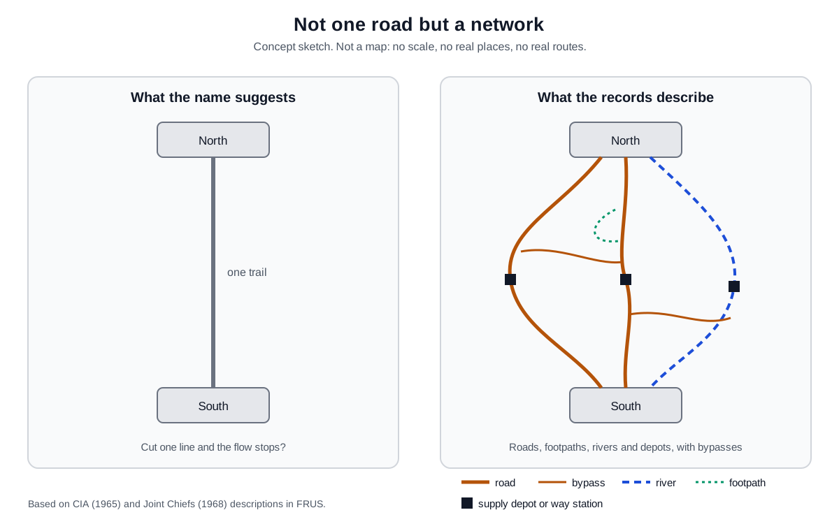
Why does a network matter? If there is one road, cutting it at one point stops the flow. In a network, traffic goes around a blocked branch.
Real life was less tidy than the sketch, because weather, terrain, trucks and people all played a part. Still, this difference comes up again and again in the story of the effort to cut the route.
From footpaths to truck roads
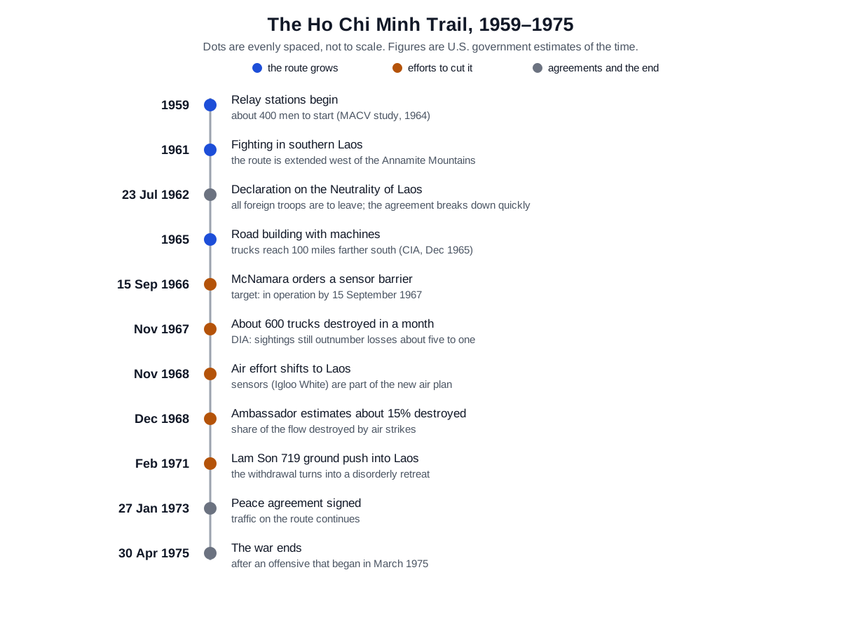
It started small. The 1964 MACV study says that in 1959 North Vietnam sent several units into Laos to clear areas of southern Laos next to the Vietnamese border. Elements of the North Vietnamese army's 70th Transportation Group followed and set up relay stations linking southern North Vietnam with northern South Vietnam.
That unit had roughly 400 men at the start in 1959. By 1964 it had grown to roughly 2,000 men plus porters, who ran about 20 stations.
How many people went south on these paths? Using prisoner interviews and captured documents, the same study counted over 34,000 men who had entered South Vietnam. It judged that its information was 10% to 66% incomplete depending on the year, about 30% on average, so the total since 1959 could be as high as 45,000. The figure comes with its own warning about the gaps.
In 1965 the character of the route changed. According to the December 1965 CIA memo, North Vietnam shipped earth-moving machines to the road work in the panhandle for the first time and kept building through the summer monsoon. Trucks could now drive 100 miles (about 160 km) farther south than before, as far as the South Vietnamese border southeast of Da Nang. Wet weather also cut the roads less often.
The route was protected in new ways too. Alternate roads and bypasses made the system less vulnerable to air attack. Aerial photos showed one stretch of new road hidden under a trellis covered with vines. Convoys moved almost only at night, and a route once walked on foot had become a truck-based logistics system.
A route through neutral Laos
The route ran through Laos rather than straight south, and politics was part of the reason. For President-elect John F. Kennedy, the first foreign policy crisis was not Berlin or Cuba but Laos.
In 1961, the Pathet Lao took until May 3 to accept a ceasefire offer. In that time the North Vietnamese army pushed into southern Laos. It captured the crossroads village of Tchepone and the ground it needed to stretch the trail west of the Annamite Mountains.
On July 23, 1962, the Geneva conference agreed on a declaration that Laos would be neutral. The declaration and its protocols required every foreign soldier, regular or irregular, every foreign paramilitary unit and all foreign military personnel to leave Laos. An international commission of India, Poland and Canada was to supervise the withdrawal.
The agreements broke down quickly. On August 27, North Vietnam pulled out 15 troops as a symbolic step, and on October 9 it said its troops had left. Even so, it kept widening its hold on southern Laos to protect the supply lines feeding the fighting in South Vietnam.
The United States pulled out its military advisers as the agreement required. Afterward it answered the North Vietnamese violations by supporting Hmong and Thai forces and the government of Souvanna Phouma. On paper Laos was neutral, but its eastern mountains became a back road of the war in South Vietnam.
A CIA memo to the 303 Committee in September 1966 estimated that about 70,000 North Vietnamese personnel had been committed in Laos since the fall of 1965. That number covered two tasks together: taking control of northern Laos, and building and keeping up the road network through the panhandle.
Trying to cut it from the air
The first American tool was to cut the route from the air, a mission called interdiction. A telegram of November 29, 1967, from Wheeler, chairman of the Joint Chiefs of Staff, to the U.S. commander in Vietnam shows the mood of the time. The Defense Intelligence Agency (DIA) had confirmed about 600 trucks destroyed in the panhandle that month, and about 95% of those results came at night.
The same numbers were read in different ways. Sullivan, the U.S. ambassador to Laos, thought that hardly any dry-season cargo was getting as far south as the Route 9 area. He expected North Vietnam to run short of trucks soon. DIA called that conclusion optimistic.
From November 1 to 25, trucks sighted outnumbered trucks damaged or destroyed by about five to one. DIA also estimated that more than 300 trucks were working that sector, backed by about 2,000 more.
In November 1968, the United States stopped bombing North Vietnam itself and turned that air power toward Laos. A November 4 cable from the U.S. embassy in Vientiane reported that sorties in the panhandle had risen from about 100 a day to 250 a day. It expected more once Commando Hunt and other operations began.
A November 20 memo from McConnell, then acting chairman of the Joint Chiefs, explained why so many aircraft were needed. Laos had so many bypasses and alternate routes that few roads could be closed completely by bombing. So a plan using about 12,000 sorties a month against the whole network began on November 15.
How much did it achieve? On December 31, 1968, Ambassador Sullivan wrote that, by the current record, air strikes were destroying about 15% of the traffic on the trail. Even the highest Air Force claims, he added, did not go above 20%.
There was a wide gap between the idea of cutting the route and the share actually destroyed. The article on precision-guided bombs explains the basic idea of how guided weapons tried to change this problem.
A barrier that listened
Another idea grew alongside the bombing: if the route was hard to see, listen for it. On September 15, 1966, Secretary of Defense McNamara put Starbird, who led the Defense Communications Agency, in charge of Joint Task Force 728. Its job was a system in South Vietnam and Laos that would halt, or at least cut deeply into, the movement of people and supplies southward. The goal was to have it working by September 15, 1967.
In the concept attached to the order, the first system against vehicles would place acoustic detectors along the truck roads, with patrol aircraft listening 24 hours a day. The order said a better acoustic sensor than any then available had to be developed, and it put the cost of the first system at about $800 million per year. The flow ran in four steps: a sensor hears, an aircraft relays, analysts read the pattern, and people decide.
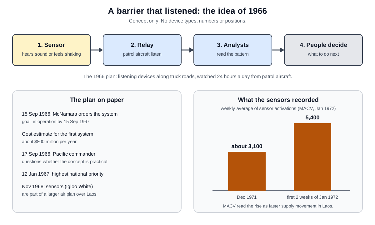
There were doubts inside the military. A Joint Chiefs memo of September 17, 1966, reported that the Pacific commander questioned whether the concept was practical. The Joint Chiefs wrote that the system's ability to meet its goal was still unsettled. Its parts and techniques, they added, would be useful whatever happened to the project as a whole.
On November 14, McNamara told President Johnson that an air barrier was needed west of the ground barriers, but its exact form had not been decided. In January 1967, on the 12th, the President gave the program, called Practice Nine, the country's top priority rating. By McConnell's memo of November 1968, placing and monitoring seismic and acoustic sensors under the name Igloo White had become one part of the air plan over Laos. An idea that began as a separate barrier had become the eyes and ears feeding a bombing campaign.
The 1971 ground push and after
In 1971, President Nixon ordered an offensive across the whole theater to take the initiative. In early February, South Vietnamese troops moved into Cambodia and Laos. North Vietnam had seen the Laos operation, called Lam Son 719, coming and had gathered its forces. The South Vietnamese pullback broke down into a disorderly retreat.
Measuring the operation's effect on supplies was not easy either. At a White House meeting on February 26, 1971, Nixon asked about press reports that DIA and CIA sharply disagreed over how much traffic was moving. CIA Director Helms answered that the two agencies worked together, and Secretary of Defense Laird said DIA put the supply figures higher than CIA did.
A March 16 meeting came back to the gap between the two estimates. It also took up how hard it was to compare data across years and to judge the impact of Lam Son.
The sensors kept recording movement on the route. In a message of January 20, 1972, Abrams, the MACV commander, reported the weekly average of sensor activations. It rose from about 3,100 in December 1971 to 5,400 in the first two weeks of January 1972. In his view the interdiction campaign, Commando Hunt VII, had damaged the buildup, but it had lost strength as aircraft were sent to other missions.
Late that March, North Vietnam launched an attack along three lines in South Vietnam. Americans called it the Easter Offensive.
What remained
The peace agreement was signed on January 27, 1973. Neither Vietnamese side kept to it, and the war went on. On March 15, Kissinger told the U.S. ambassador in Laos that troops and equipment were still moving along the trail at a high level. He saw the traffic following the patterns from before the agreement and called it a breach of the agreement's Articles 7 and 20.
The Office of the Historian notes that North Vietnamese forces rebuilt their units and improved their supply system before starting a large offensive in the Central Highlands in March 1975. The war effectively ended on April 30, 1975, when North Vietnamese tanks drove through the gate of the presidential palace in Saigon.
Something else remained in Laos. Speaking there in September 2016, President Obama said the United States had dropped over two million tons of bombs on Laos in the nine years from 1964 to 1973. That was more than the total for Germany and Japan together in World War II. Measured per person, it left Laos the most heavily bombed country in history, and the figure covers all of Laos, not only the Ho Chi Minh Trail.
Many of those bombs never exploded. Thousands of Laotians have since been killed or injured by them, among them farmers working their fields and children at play. In the same speech, Obama announced that U.S. funding to clear unexploded bombs would double to $90 million a year over the next three years. Traces of the fight to cut a supply route are still in the ground and still touch people's lives long after the war.
The Ho Chi Minh Trail was less a single road than a network that was always being repaired and split. The U.S. records themselves show how hard it was even to measure the effort to cut it. More lasting than any count of destroyed trucks is the fact that agencies argued over what those counts meant.
What to read next
- Military logistics: why supply sets the pace of a war, starting from the basics.
- Precision-guided bombs: how bombing that covered wide areas turned into weapons aimed at a single point.
- Ia Drang and Helicopter Air Mobility: how helicopters carried troops and supplies in the same war.