On February 10, 2009, two satellites struck each other 790 km above the far north of Siberia. One was Iridium 33, a working U.S. communications satellite. The other was Cosmos 2251, a Russian communications satellite that had already been retired. It was the first time two intact spacecraft had collided by accident at very high speed.
A satellite does not always vanish when its job is done. It can stay in orbit, and it can cross the path of a satellite that is still working. Finding out what passes near a satellite, and helping it get out of the way before a crash, is the work called space situational awareness. This article follows its official meaning, its public history and the rules around it.
What "space situational awareness" means
The official definition of space situational awareness (SSA) comes from Space Policy Directive-3 (SPD-3), issued by the U.S. president on June 18, 2018. SSA is knowing and characterizing space objects and the environment they operate in, so that space activities stay safe, stable and sustainable. In other words, it means knowing what is where and how it moves.
The same directive gives a separate definition for space traffic management (STM). STM means planning activities in space, coordinating them, and keeping them in step while in orbit. If SSA is the knowing, STM is using that knowledge so that objects stay out of each other's way.
On a road, SSA would be the traffic map and STM the signals and traffic rules. Space is different. There are no lanes or traffic lights, and a dead satellite or a fragment cannot steer out of the way on its own.
A word that comes up often in this field is conjunction. It means two or more objects meeting at one spot in space at one moment, or very nearly so. SPD-3 noted that, already in 2018, the U.S. Department of Defense tracked more than 20,000 objects in space. It also put out a list of those objects and warned operators of possible conjunctions.
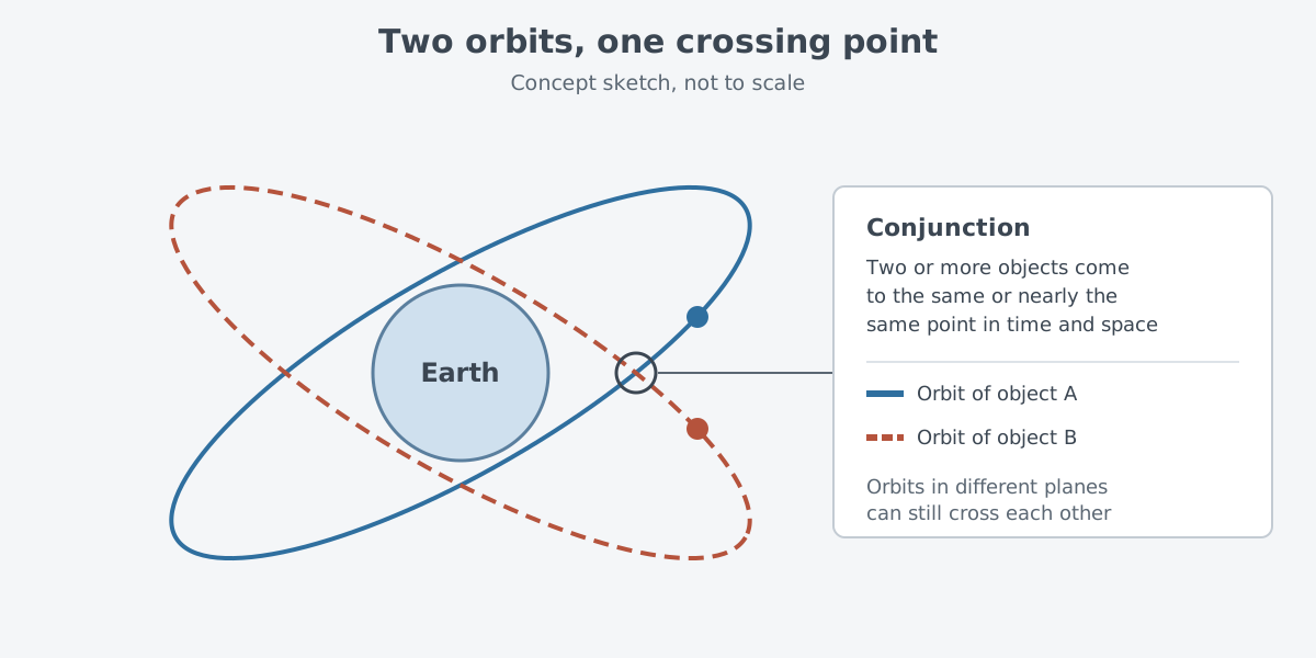
Two orbits in different planes still cross somewhere. In the 2009 collision, the orbital planes of the two satellites crossed at nearly a right angle, and the collision speed was more than 11 km per second.
What is in orbit
Orbital debris means objects made by people that circle Earth but no longer do anything useful. As of August 2026, the catalog of the U.S. Space Surveillance Network (SSN) listed over 34,000 objects circling Earth. The list holds not only working satellites but also dead satellites, used rocket bodies and fragments.
Far more objects are not on the list. NASA's Orbital Debris Program Office (ODPO) estimates that there are 100 million pieces of debris about a millimeter in size. The smaller the size, the faster the count grows, so most debris is too small to be tracked on a routine basis.
Debris is not spread out evenly either. Most of it circles within 2,000 km of Earth's surface. In this low Earth orbit, debris moves at 7–8 km per second, so even a hit from a small piece carries a lot of energy.
Once debris forms, it does not go away quickly. Below 600 km, debris usually falls back within several years. At 800 km, it often takes centuries for the orbit to sink. Above 1,000 km, debris usually stays up for at least 1,000 years.
A warning from 1978
In June 1978, Donald J. Kessler and Burton G. Cour-Palais of NASA's Johnson Space Center published a paper in the Journal of Geophysical Research. Its title was "Collision frequency of artificial satellites - The creation of a debris belt."
The core idea is a chain reaction. More satellites mean a higher chance that satellites hit each other. Each fragment from a collision then raises the chance of the next one. Repeated over and over, this could grow a belt of debris around Earth, and that was the paper's warning.
The paper projected that, under certain conditions, such a belt could start to form within the 20th century and become a serious problem in the 21st. It also offered a remedy. Bringing in launch limits and operating procedures early could greatly delay the belt.
Collisions and breakups that actually happened
NASA's ODPO names explosions and collisions of spacecraft and launch vehicles as major sources of large fragments. Two events in particular added a great deal of large debris to Earth orbit. One was the deliberate destruction of Fengyun-1C, a weather satellite, in 2007. The other was the accidental crash between Iridium 33 and Cosmos 2251 in 2009.
On January 11, 2007, China hit Fengyun-1C, one of its own old weather satellites, in an anti-satellite (ASAT) test. In its April 2007 issue, NASA's orbital debris newsletter called the cloud the worst single event polluting low Earth orbit in the 50 years up to then.
The pieces reached altitudes between 200 km and over 4,000 km. Within two months, over 1,200 of them were in the official catalog. Most of them went into orbits where they will stay for decades or even centuries.
From the 2009 collision, 823 large pieces were identified and added to the catalog by the end of March. Many of them are expected to stay in orbit for decades, so they remain a collision hazard for other satellites in low Earth orbit.
On November 15, 2021, Russia struck Cosmos 1408, one of its own satellites, in a test of a direct-ascent anti-satellite (DA-ASAT) missile. According to NOAA's Office of Space Commerce (OSC), the test had by then left over 1,500 trackable pieces of debris. It will likely create hundreds of thousands of smaller pieces. General James Dickinson of U.S. Space Command said the debris would remain a threat for years and would force more collision avoidance maneuvers.
After the test, U.S. Space Command kept watching the paths of this debris. The information is posted at space-track.org.
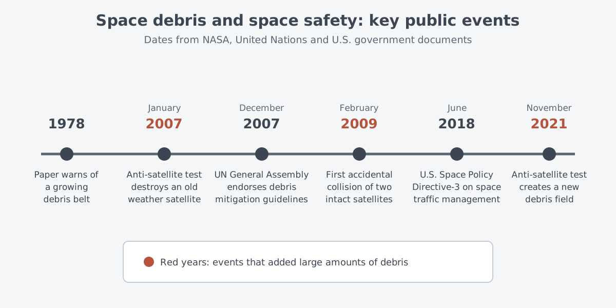
Of the three events, two were deliberate tests that destroyed a satellite and one was an accident. The causes differ, but each left behind fragments that stay in orbit for a long time.
Three steps to avoid a collision
Avoiding a collision starts with prediction. NASA's Conjunction Assessment Risk Analysis (CARA) team calls the satellite it protects the "primary" object and every other known object in space a "secondary" object. It then compares where they will be. This assessment starts from screenings run by the U.S. Space Force's 18th Space Defense Squadron.
There are three steps. First, predict which objects will come close and when. Next, assess the collision risk of each close approach. The last step, reducing the risk, is used for close approaches that show a high collision risk.
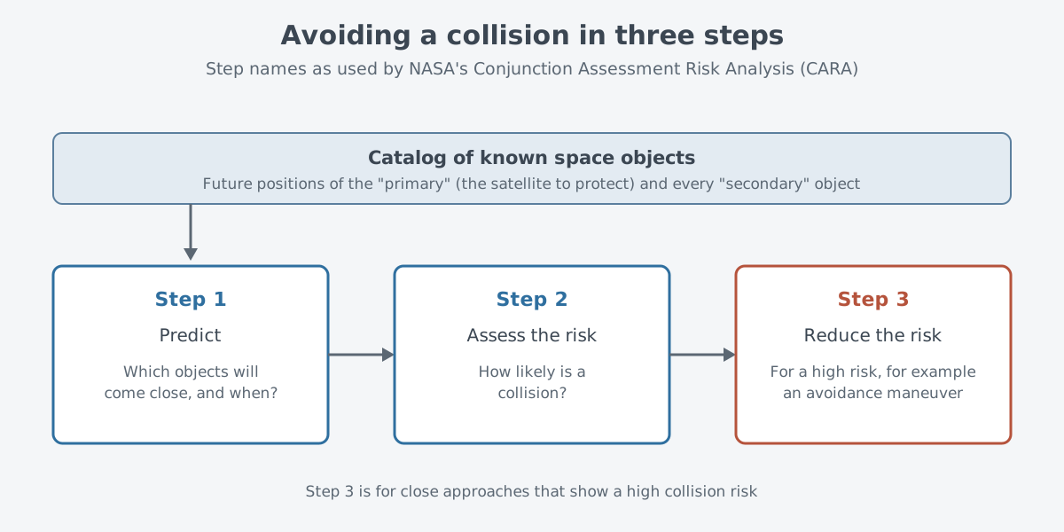
The International Space Station (ISS) is a good example. If a tracked object is predicted to pass near the station and the collision risk is above a set limit, the station normally moves out of the way. According to NASA's ODPO, the station has moved to dodge objects in this way 41 times since 1999.
There is not always time to move. On March 12, 2009, a prediction that a small piece of debris would pass close to the station came late, so the crew briefly moved into their Soyuz TMA-13 spacecraft. In the end the object passed almost 4 km away. In cases like this, the crew moves to the return vehicle and prepares to leave the station fast in case the rare hit does happen.
Rules and policy
There is no international treaty on orbital debris. Instead, the major space agencies set up the Inter-Agency Space Debris Coordination Committee (IADC). The Scientific and Technical Subcommittee of the UN Committee on the Peaceful Uses of Outer Space (COPUOS) has also discussed debris since 1994, and both bodies have published mitigation guidelines.
The UN guidelines were adopted by the subcommittee in 2007 and endorsed by the UN General Assembly in resolution 62/217 on December 22, 2007. They are voluntary, and the General Assembly invited member states to carry them out through their own national mechanisms.
There are seven guidelines. Guideline 3 asks for a lower chance of accidental collision. If orbital data show a possible collision, moving the launch time or making an avoidance maneuver in orbit should be considered. Guideline 4 says activities that create long-lived debris, such as deliberately destroying spacecraft and rocket stages in orbit, should be avoided.
In the United States, SPD-3 set the main direction: users should not pay direct fees for basic SSA data and basic STM services, within national security limits. The Secretary of Defense maintains the official master list of space objects. However, SPD-3 said some of this work should go to a civil agency, the Department of Commerce. That covers the publicly releasable part of the catalog, an open data repository and the collision avoidance support service.
The next step is the Traffic Coordination System for Space (TraCSS) of NOAA's Office of Space Commerce. It is being built to give civil and private satellite operators basic SSA data and services for spaceflight safety. In a September 8, 2025 update, the office presented this work as delivering on SPD-3.
Where this meets lasers: measuring to satellites with light
A laser can also measure the distance to a satellite. Satellite laser ranging (SLR) uses short-pulse lasers, optical receivers and timing electronics. It times how long light takes to travel from a ground station to a reflector array on the satellite and back, and turns that time into a distance.
This work is coordinated by the International Laser Ranging Service (ILRS), which works under the International Association of Geodesy (IAG). The ILRS formed a Space Debris Study Group on October 26, 2014. Several SLR stations now track space debris, and interest in this work from space agencies is growing fast.
The idea of measuring distance from the round-trip time of light is explained step by step in Measuring with lasers: range finding and lidar basics.
What to read next
- Reconnaissance satellites: information from orbit: what satellites in orbit actually do.
- Measuring with lasers: range finding and lidar basics: how the round-trip time of light gives a distance.
- Finding open sources: where to look for government reports, papers and standards: how to find and read government and international documents like the ones used here.